PROVISIONAL DATA SUBJECT TO REVISION
Click to hidestation-specific text
|
 |
LOCATION.--Lat 39°39'05.0", long 75°35'12.7",
New Castle County, DE, Hydrologic Unit 02040205, at mouth of Army Creek, on river side
of tidal gate.
DRAINAGE AREA.--Not determined.
PERIOD OF RECORD.--April 2012 to current year.
REVISIONS HISTORY.--https://waterdata.usgs.gov/nwis/dv/?site_no=01482170: 2015.
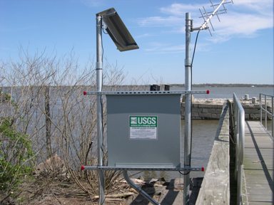
GAGE.--Water-stage recorder. Datum of gage is 0.00 ft above North American Vertical Datum
of 1988. Prior to July 10, 2019, at site 1.4 miles northeast from current location, on right
bank at end of pier in Battery Park, 250 ft downstream from end of Delaware Ave.
REMARKS.--This is a tidal station. Discharge is not determined at this location. U.S. Geological
Survey satellite data-collection platform at station.
EXTREMES FOR PERIOD OF RECORD.--Maximum elevation, 7.2 ft, Oct. 30, 2012 (from high-water mark);
minimum elevation, unknown.
COOPERATION.--Funding for this station is provided by the Delaware Geological Survey.
Summary of all available data for this site
Instantaneous-data availability statement

