USGS 05484800 Walnut Creek at Des Moines, IA

PROVISIONAL DATA SUBJECT TO REVISION

Click to hidestation-specific text

> Site Information

> National Weather Service River Forecast

Funding For This Site Provided By:

Link to Upstream Gage

Iowa WSC Gage Network

Link to Downstream Gage


This station managed by the Fort Dodge Field Office.

Available Parameters Available Period
  
1990-10-01  2026-06-10
2007-10-01  2026-06-10


 (7)
 

  -- or --


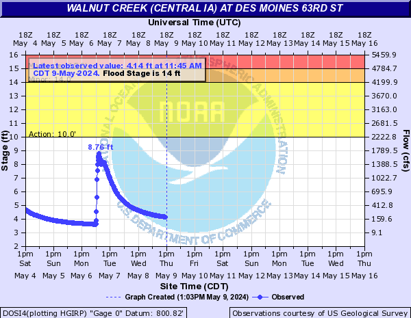
Summary of all available data for this site
Instantaneous-data availability statement


Discharge, cubic feet per second

Most recent instantaneous value: 92.8 06-10-2026   13:45 CDT
Graph of  Discharge, cubic feet per second

Add up to 2 more sites and replot for "Discharge, cubic feet per second"

?


Create presentation-quality / stand-alone graph.   Subscribe to WaterAlert      

See this graph on the Monitoring Location Pages


Daily discharge, cubic feet per second -- statistics for Jun 10 based on 54 water years of record more
Min
(1977)
25th
percen-
tile
Median Most Recent
Instantaneous
Value Jun 10
75th
percen-
tile
Mean Max
(2011)
0.10 34 72 92.8 133 157 1990


Gage height, feet

Most recent instantaneous value: 3.83 06-10-2026   13:45 CDT
Graph of  Gage height, feet

Add up to 2 more sites and replot for "Gage height, feet"

?


Create presentation-quality / stand-alone graph.   Subscribe to WaterAlert      

See this graph on the Monitoring Location Pages