USGS 05458300 Cedar River at Waverly, IA

PROVISIONAL DATA SUBJECT TO REVISION

Click to hidestation-specific text

> Site Information

> National Weather Service River Forecast

Funding For This Site Provided By:

Link to Upstream Gage

Iowa WSC Gage Network

Link to Downstream Gage


This station managed by the Iowa City Field Office.

Available Parameters Available Period
  
2011-10-01  2025-12-17
2000-08-31  2025-12-17
2007-10-01  2025-12-17
2025-08-19  2025-12-17
2025-08-19  2025-12-17


 (31)
 

  -- or --


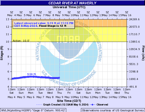
Summary of all available data for this site
Instantaneous-data availability statement


Temperature, water, degrees Celsius

Most recent instantaneous value: 1.0 12-17-2025   21:15 CST
Graph of  Temperature, water, degrees Celsius

Add up to 2 more sites and replot for "Temperature, water, degrees Celsius"

?


Create presentation-quality / stand-alone graph.   Subscribe to WaterAlert      

See this graph on the Monitoring Location Pages


Discharge, cubic feet per second, [from VELQ]

Most recent instantaneous value: Ice 12-17-2025   21:15 CST
Graph of  Discharge, cubic feet per second, [from VELQ]

Add up to 2 more sites and replot for "Discharge, cubic feet per second, [from VELQ]"

?


Create presentation-quality / stand-alone graph.   Subscribe to WaterAlert      

See this graph on the Monitoring Location Pages


Gage height, feet

Most recent instantaneous value: 5.10 12-17-2025   21:15 CST
Graph of  Gage height, feet

Add up to 2 more sites and replot for "Gage height, feet"

?


Create presentation-quality / stand-alone graph.   Subscribe to WaterAlert      

See this graph on the Monitoring Location Pages


Gage height, feet, [Argonaut]

Most recent instantaneous value: 4.45 12-17-2025   21:15 CST
Graph of  Gage height, feet, [Argonaut]

Add up to 2 more sites and replot for "Gage height, feet, [Argonaut]"

?


Create presentation-quality / stand-alone graph.   Subscribe to WaterAlert      

See this graph on the Monitoring Location Pages


Mean water velocity for discharge computation, feet per second, [mean]

Most recent instantaneous value: 0.27 12-17-2025   21:15 CST
Graph of  Mean water velocity for discharge computation, feet per second, [mean]

Add up to 2 more sites and replot for "Mean water velocity for discharge computation, feet per second, [mean]"

?


Create presentation-quality / stand-alone graph.   Subscribe to WaterAlert      

See this graph on the Monitoring Location Pages