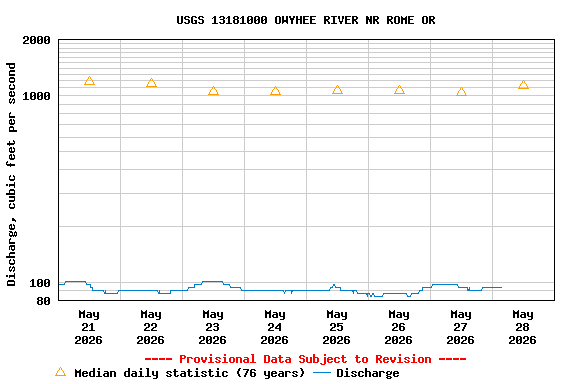
USGS 13181000 OWYHEE RIVER NR ROME OR

PROVISIONAL DATA SUBJECT TO REVISION

Click to hidestation-specific text

Station operated in cooperation with Bonneville Power Administration.

NOTE: River forecasts and additional data can be obtained at the 
National Weather Service's Advanced Hydrologic Prediction Services web page.
NOTE: The most current shifted rating for this site can be found at USGS Rating Depot website.
Boating safety tips
Available Parameters Available Period
  
1992-10-07  2025-02-16
2007-10-01  2025-02-16


 (7)
 

  -- or --


Summary of all available data for this site
Instantaneous-data availability statement


Discharge, cubic feet per second

Most recent instantaneous value: 416 02-16-2025   17:30 MST
Graph of

Add up to 2 more sites and replot for "Discharge, cubic feet per second"

?


Create presentation-quality / stand-alone graph.   Subscribe to WaterAlert      

See this graph on the Monitoring Location Pages


Daily discharge, cubic feet per second -- statistics for Feb 16 based on 75 water years of record more
Min
(1955)
25th
percen-
tile
Most Recent
Instantaneous
Value Feb 16
Median Mean 75th
percen-
tile
Max
(1982)
137 276 416 556 1060 1290 7630


Gage height, feet

Most recent instantaneous value: 2.04 02-16-2025   17:30 MST
Graph of

Add up to 2 more sites and replot for "Gage height, feet"

?


Create presentation-quality / stand-alone graph.   Subscribe to WaterAlert      

See this graph on the Monitoring Location Pages