PROVISIONAL DATA SUBJECT TO REVISION
Click to hidestation-specific text
For information about dam operations, call 1-888-457-4076 or contact Constellation Energy (http://www.constellationenergy.com/)
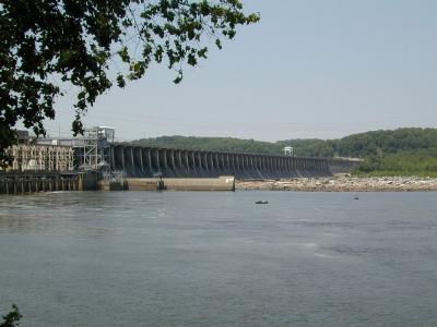
LOCATION.-- Lat 39°39'28.4", long 76°10'28.0", Harford County, MD, Hydrologic Unit 02050306,
   1.0 mi southwest of Conowingo, and 9.9 mi upstream from mouth.
DRAINAGE AREA.--27,100 mi2
PERIOD OF RECORD.--October 1967 to current year.
GAGE.--Water-stage recorder.  Datum of gage is 4.16 ft above North American Vertical Datum of 1988.
REMARKS.--Flow regulated by Conowingo Reservoir beginning October 1928, usable capacity, 55,070,000,000 gal;
   dead storage, 45,290,000,000 gal. Records do not include a small infrequent diversion upstream from station to
   augment municipal supply of city of Baltimore. Records of diversion available from Baltimore City Department
   of Public Works. U.S. Geological Survey satellite data-collection platform at station.
EXTREMES FOR PERIOD OF RECORD.--Maximum discharge, 1,130,000 ft3/s, June 24, 1972,
   gage height, 36.83 ft; minimum discharge, 144 ft3/s, Mar. 2, 1969.
COOPERATION.--Funding for the operation of this station is provided by Constellation Energy Generation.
   Access to gage site provided by Constellation Energy Generation.
| Boating safety tips |
Summary of all available data for this site
Instantaneous-data availability statement

