USGS 04065650 STURGEON RIVER AT US HWY-2 AT LORETTO, MI

PROVISIONAL DATA SUBJECT TO REVISION

Click to hidestation-specific text

The Water-Year Summary provides additional information for most sites, and can be accessed via the "Available data for this site" drop-down list.

Station operated in cooperation with the City of Norway.


This station managed by the UPPER PENINSULA FIELD OFFICE.

Available Parameters Available Period
  
2011-03-31  2026-01-29
2011-03-30  2026-01-29
2023-01-30  2026-01-29


 (31)
 

  -- or --


Summary of all available data for this site
Instantaneous-data availability statement

Discharge, cubic feet per second
 
-- Data temporarily unavailable for the time period specified --


Gage height, feet

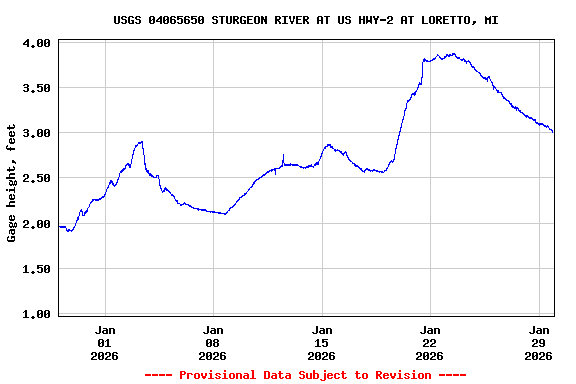
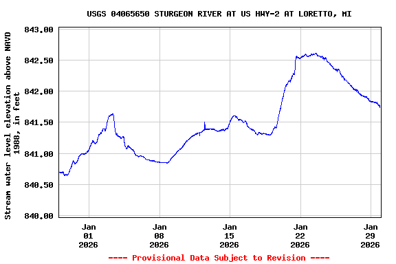
Most recent instantaneous value: 3.02 01-29-2026   21:00 CST
Graph of  Gage height, feet

Add up to 2 more sites and replot for "Gage height, feet"

?


Create presentation-quality / stand-alone graph.   Subscribe to WaterAlert      

See this graph on the Monitoring Location Pages


Stream water level elevation above NAVD 1988, in feet

Most recent instantaneous value: 841.76 01-29-2026   21:00 CST
Graph of  Stream water level elevation above NAVD 1988, in feet

Add up to 2 more sites and replot for "Stream water level elevation above NAVD 1988, in feet"

?


Create presentation-quality / stand-alone graph.   Subscribe to WaterAlert      

See this graph on the Monitoring Location Pages