PROVISIONAL DATA SUBJECT TO REVISION
Click to hidestation-specific text
|
Operated in cooperation with the Additional Information: |

Summary of all available data for this site
Instantaneous-data availability statement
|
Operated in cooperation with the Additional Information: |
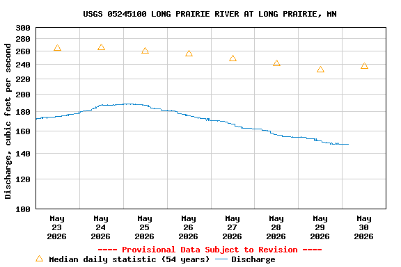
| Min (1976) | Most Recent Instantaneous Value May 30 | 25th percen- tile | Median | Mean | 75th percen- tile | Max (2012) |
|---|---|---|---|---|---|---|
| 50.0 | 148 | 172 | 237 | 282 | 397 | 647 |
![]() U.S. Department of the Interior |
U.S. Geological Survey
U.S. Department of the Interior |
U.S. Geological Survey
Title: USGS Current Conditions for Minnesota
URL:
Page Contact Information: Minnesota Water Data Support Team
Page Last Modified: 2026-05-30 04:52:47 EDT
3.44 2.97 sdww01