PROVISIONAL DATA SUBJECT TO REVISION
Click to hidestation-specific text
|
Operated in cooperation with the Additional Information: |

Summary of all available data for this site
Instantaneous-data availability statement
|
Operated in cooperation with the Additional Information: |
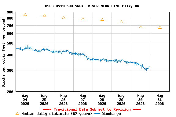
| Min (1955) | 25th percen- tile | Most Recent Instantaneous Value May 31 | Median | Mean | 75th percen- tile | Max (2012) |
|---|---|---|---|---|---|---|
| 160 | 307 | 325 | 671 | 1090 | 1480 | 7220 |
![]() U.S. Department of the Interior |
U.S. Geological Survey
U.S. Department of the Interior |
U.S. Geological Survey
Title: USGS Current Conditions for Minnesota
URL:
Page Contact Information: Minnesota Water Data Support Team
Page Last Modified: 2026-05-31 00:24:08 EDT
1.27 0.99 caww02