USGS 10338000 TRUCKEE R NR TRUCKEE CA

PROVISIONAL DATA SUBJECT TO REVISION

Click to hidestation-specific text
Click to enlarge
Site Photo
> Rating Information
This station managed by the Truckee Field Office.

Available Parameters Available Period
  
1992-10-08  2024-03-18
2007-10-01  2024-03-18


 (7)
 

  -- or --


Summary of all available data for this site
Instantaneous-data availability statement
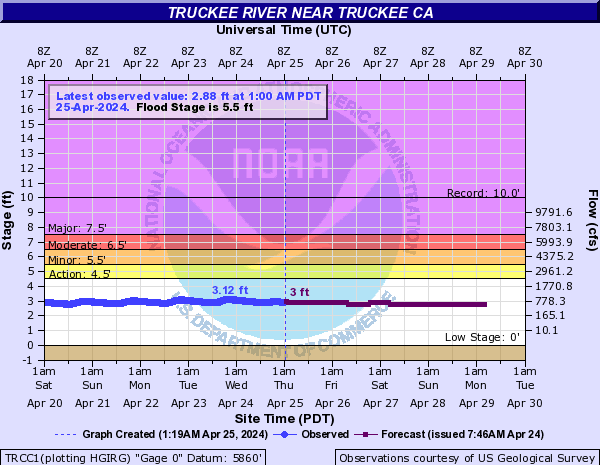

Discharge, cubic feet per second

Most recent instantaneous value: 131 03-18-2024   22:30 PDT
Graph of  Discharge, cubic feet per second

Add up to 2 more sites and replot for "Discharge, cubic feet per second"

?


Create presentation-quality / stand-alone graph.   Subscribe to WaterAlert      

See this graph on the Monitoring Location Pages


Daily discharge, cubic feet per second -- statistics for Mar 19 based on 52 water years of record more
Min
(2015)
25th
percen-
tile
Most Recent
Instantaneous
Value Mar 19
Median Mean 75th
percen-
tile
Max
(1952)
65.8 116 131 168 291 298 1450


Gage height, feet

Most recent instantaneous value: 1.88 03-18-2024   22:30 PDT
Graph of  Gage height, feet

Add up to 2 more sites and replot for "Gage height, feet"

?


Create presentation-quality / stand-alone graph.   Subscribe to WaterAlert      

See this graph on the Monitoring Location Pages