Funding for this site is provided by:
 STATION.
--01577500 MUDDY CREEK NEAR CASTLE FIN,
PA
LOCATION.--Lat 39°46'21", long
76°18'58" referenced to North American Datum of 1927, York
County, PA, Hydrologic Unit 02050306, bridge on SR 2024 (Paper Mill
Rd), 0.8 mi northeast of Castle Fin, and approximately 1 mi east of the
intersection of SR 2024 and State Highway 74.
DRAINAGE AREA.--133 square miles.
PERIOD OF RECORD.--October 1928 to September 1939 and
April 1968 to September 1971. January 1989 to September 1995 and
October 2010 to March 2014 (discharge measurements). April 2014 to
current.
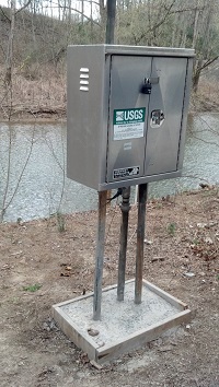
GAGE.--Water-stage recorder, crest-stage gage and
water-quality monitor. Elevation of gage is 175.42 ft above National
Geodetic Vertical Datum of 1929. Satellite telemetry at station.
COOPERATION.--Station established and maintained by
the U.S. Geological Survey in cooperation with the U.S. Environmental
Protection Agency, and the County of York.
GAGE HEIGHTS OF IMPORTANCE.--
Supplied by USGS.-- Operational limit of
instrumentation - 18.5 ft.

