Warning: Javascript must be enabled to use all the features on this page!


Page Loading - Please Wait...

Click to hideNews Bulletins

USGS 01471980 Manatawny Creek near Pottstown, PA

PROVISIONAL DATA SUBJECT TO REVISION

Click to hidestation-specific text

THIS SITE WAS DISCONTINUED ON SEPTEMBER 30, 2007.
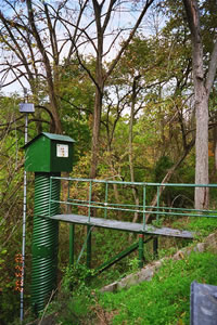
Station gage imageSTATION.--01471980 MANATAWNY CREEK NEAR POTTSTOWN, PA
LOCATION.--Lat 40`16'22", long 75`40'49", Berks County, Hydrologic Unit 02040203, on left bank 180 ft upstream from bridge on Manatawny Street, 0.7 mi downstream from Ironstone Creek, 2.4 mi northwest of Pottstown, 3.1 mi upstream from mouth, and 4.7 mi southwest of Boyertown.
DRAINAGE AREA.--85.5 square miles.
PERIOD OF RECORD.--August 1974 to September 2007.
GAGE.--Water-stage recorder. Datum of gage is 150.00 ft above National Geodetic Vertical Datum of 1929 (levels by U.S. Army Corps of Engineers).
REMARKS.--Only annual peaks were published after September 2004.
COOPERATION.--Funding for the operation of this station is provided by the U.S. Army Corps of Engineers.
Available Parameters Period of Record
  
1974-08-01  2004-09-30


 (365)
 

  -- or --


Summary of all available data for this site
Instantaneous-data availability statement
*** There are no data available on the Waterdata system for the time period specified,
    although data may be available in the files of the local USGS office operating the station.