Funding for this site is provided by:
 STATION.
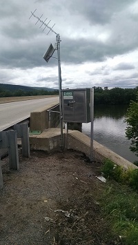
--01553025 WEST BRANCH SUSQUEHANNA RIVER AT
ALLENWOOD, PA
LOCATION.--Lat 41`06'29", long
76`53'24", Union County, Hydrologic Unit 02050206, on left
bank, on upstream side of bridge on State Route 44 near Allenwood,
PA.
DRAINAGE AREA.--6,496 square miles.
PERIOD OF RECORD.--Water-quality sample, June 2008;
Continuous stage/ discharge from July 2015 to current year.
GAGE.--Water-stage recorder, crest-stage gage, and
radar unit. Datum of gage is 441.2 ft above North American Vertical
Datum of 1988, from GPS survey. Satellite telemetry at station.
COOPERATION.--Funding for the operation of this
station is provided by the U.S. Geological Survey.
REMARKS.--Flow slightly regulated by 6 flood-control
reservoirs, which have a combined capacity of 440,200 acre-ft.

