Funding for this site is provided by:
 STATION.
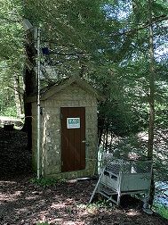
--03034500 LITTLE MAHONING CREEK AT
McCORMICK, PA
LOCATION.--Lat 40`50'10", long
79`06'37", Indiana County, Hydrologic Unit 05010006, on left
bank 200 ft upstream from highway bridge at McCormick, 1 mi west of
Georgeville, 1.7 mi upstream from Ross Run, and 4 mi southeast of
Smicksburg.
DRAINAGE AREA.--87.4 square miles.
PERIOD OF RECORD.--October 1939 to current year.
GAGE.--Water-stage recorder. Datum of gage is 1,163.9
ft above North American Vertical Datum of 1988 Prior to May 10, 1940,
non-recording gage at site 200 ft upstream at same datum. Prior to
November 2, 2023, the datum of gage was erroneously reported as 1164.88
ft above National Geodetic Vertical Datum of 1929. Satellite telemetry
at station.
COOPERATION.--Station established and maintained by
the U.S. Geological Survey. Funding for the operation of this station
is provided by the U.S. Army Corps of Engineers, Pittsburgh District,
the Pennsylvania Department of Environmental Protection, and the U.S.
Geological Survey.


