Funding for this site is provided by:
 STATION.
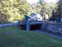
--03049800 LITTLE PINE CREEK NEAR ETNA,
PA
LOCATION.--Lat 40`31'13", long
79`56'18", Allegheny County, Hydrologic Unit 05010009, on
right bank at downstream side of highway bridge on Saxonburg Boulevard,
0.7 mi upstream from mouth, and 1.5 mi northeast of Etna.
DRAINAGE AREA.--5.78 square miles.
PERIOD OF RECORD.--October 1962 to current year.
GAGE.--Water-stage recorder and crest-stage gage.
Datum of gage is 774.0 ft above North American Vertical Datum of 1988.
Prior to Oct. 1, 1986 at datum 4.00 ft higher. Sept. 30, 1987 through
Sept. 30, 2000, at datum 1.00 ft higher. Prior to January 2, 2024, the
datum of gage was reported as 774.26 ft above National Geodetic
Vertical Datum of 1929. Satellite telemetry at station.
COOPERATION.--Station established and maintained by
the U.S. Geological Survey. Funding for the operation of this station
is provided by the Pennsylvania Department of Environmental Protection
and the U.S. Geological Survey.
GAGE HEIGHTS OF IMPORTANCE.-
Supplied by NWS: Flood stage-9 ft; Moderate flood
stage-12 ft; Major flood stage-14 ft.

