USGS 04118500 ROGUE RIVER NEAR ROCKFORD, MI

PROVISIONAL DATA SUBJECT TO REVISION

Click to hidestation-specific text

Station is a Federal Priority Streamgage and is operated as part of the Groundwater and Streamflow Information Program.
This station managed by the LANSING FIELD OFFICE.

Available Parameters Available Period
  
1989-10-01  2026-04-08
2017-10-01  2026-04-08
2020-10-13  2026-04-08


 (7)
 

  -- or --


Summary of all available data for this site
Instantaneous-data availability statement


Discharge, cubic feet per second

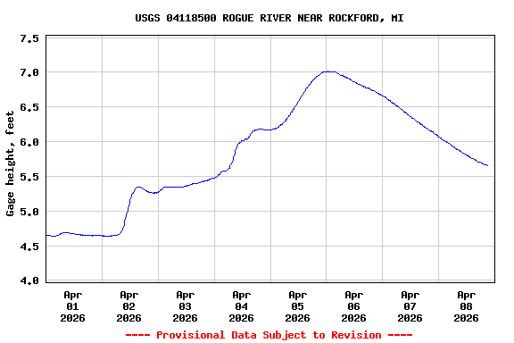
Most recent instantaneous value: 584 04-08-2026   20:00 EST
Graph of

Add up to 2 more sites and replot for "Discharge, cubic feet per second"

?


Create presentation-quality / stand-alone graph.   Subscribe to WaterAlert      

See this graph on the Monitoring Location Pages


Daily discharge, cubic feet per second -- statistics for Apr 8 based on 69 water years of record more
Min
(2000)
25th
percen-
tile
Median Mean 75th
percen-
tile
Most Recent
Instantaneous
Value Apr 8
Max
(1965)
179 274 362 420 470 584 1640


Gage height, feet

Most recent instantaneous value: 5.67 04-08-2026   20:00 EST
Graph of

Add up to 2 more sites and replot for "Gage height, feet"

?


Create presentation-quality / stand-alone graph.   Subscribe to WaterAlert      

See this graph on the Monitoring Location Pages


Stream water level elevation above NAVD 1988, in feet

Most recent instantaneous value: 630.03 04-08-2026   20:00 EST
Graph of  Stream water level elevation above NAVD 1988, in feet

Add up to 2 more sites and replot for "Stream water level elevation above NAVD 1988, in feet"

?


Create presentation-quality / stand-alone graph.   Subscribe to WaterAlert      

See this graph on the Monitoring Location Pages