USGS 12414500 ST JOE RIVER AT CALDER, ID

PROVISIONAL DATA SUBJECT TO REVISION

Click to hidestation-specific text
St. Joe River at Calder, ID - USGS file photo

The elevation of this station has been determined to be 2175.514 feet above NAVD88. To obtain stream water-surface elevation values in NAVD88 add 2175.514 feet to gage height values.

> Rating Information

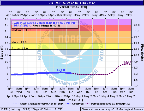
> NWS River Forecast for this site

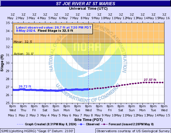
> NWS River Forecast for St. Joe River at St. Maries

Station operated in cooperation with Bonneville Power Administration.

This station managed by the Post Falls Field Office.

Available Parameters Available Period
  
1986-10-01  2010-09-30
1986-10-01  2024-04-25
2007-10-01  2024-04-25
2020-02-12  2023-05-14


 (7)
 

  -- or --


Summary of all available data for this site
Instantaneous-data availability statement


Discharge, cubic feet per second

Most recent instantaneous value: 3140 04-25-2024   20:30 PDT
Graph of  Discharge, cubic feet per second

Add up to 2 more sites and replot for "Discharge, cubic feet per second"

?


Create presentation-quality / stand-alone graph.   Subscribe to WaterAlert      

See this graph on the Monitoring Location Pages


Daily discharge, cubic feet per second -- statistics for Apr 26 based on 104 water years of record more
Min
(2008)
Most Recent
Instantaneous
Value Apr 26
25th
percen-
tile
Median Mean 75th
percen-
tile
Max
(2012)
1710 3140 4230 5840 6480 7730 18900

Discharge, cubic feet per second, [Instantaneous Data Archive]
 
-- Data temporarily unavailable for the time period specified --


Gage height, feet

Most recent instantaneous value: 7.93 04-25-2024   20:30 PDT
Graph of  Gage height, feet

Add up to 2 more sites and replot for "Gage height, feet"

?


Create presentation-quality / stand-alone graph.   Subscribe to WaterAlert      

See this graph on the Monitoring Location Pages