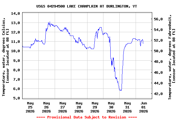
USGS 04294500 LAKE CHAMPLAIN AT BURLINGTON, VT

PROVISIONAL DATA SUBJECT TO REVISION

Click to hidestation-specific text
Station operated in cooperation with the Vermont Department of Environmental Conservation and ECHO at the Leahy Center for Lake Champlain.
Boating safety tips
Available Parameters Available Period
  
2014-10-01  2024-04-16
2023-12-18  2024-04-16
2014-10-01  2018-05-07
2014-10-01  2024-04-16
2007-10-01  2024-04-16
2021-04-17  2024-04-16


 (7)
 

  -- or --


Summary of all available data for this site
Instantaneous-data availability statement


Temperature, water, degrees Celsius, [sensor located at 88 ft]

Most recent instantaneous value: 5.4 04-16-2024   09:00 EDT
Graph of  Temperature, water, degrees Celsius, [sensor located at 88 ft]

Add up to 2 more sites and replot for "Temperature, water, degrees Celsius, [sensor located at 88 ft]"

?


Create presentation-quality / stand-alone graph.   Subscribe to WaterAlert      

See this graph on the Monitoring Location Pages


Temperature, water, degrees Fahrenheit, [sensor located at 88 ft(2)]

Most recent instantaneous value: 41.7 04-16-2024   09:00 EDT
Graph of  Temperature, water, degrees Fahrenheit, [sensor located at 88 ft(2)]

Add up to 2 more sites and replot for "Temperature, water, degrees Fahrenheit, [sensor located at 88 ft(2)]"

?


Create presentation-quality / stand-alone graph.   Subscribe to WaterAlert      

See this graph on the Monitoring Location Pages


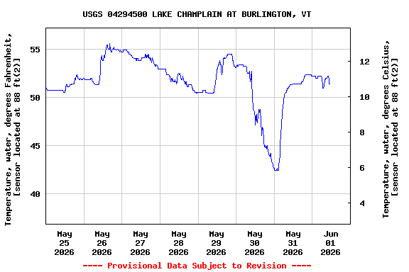
Temperature, water, degrees Fahrenheit, [sensor located at 88 ft]
 
-- Data temporarily unavailable for the time period specified --


Specific conductance, water, unfiltered, microsiemens per centimeter at 25 degrees Celsius

Most recent instantaneous value: 196 04-16-2024   09:00 EDT
Graph of  Specific conductance, water, unfiltered, microsiemens per centimeter at 25 degrees Celsius

Add up to 2 more sites and replot for "Specific conductance, water, unfiltered, microsiemens per centimeter at 25 degrees Celsius"

?


Create presentation-quality / stand-alone graph.   Subscribe to WaterAlert      

See this graph on the Monitoring Location Pages


Lake or reservoir water surface elevation above NGVD 1929, feet

Most recent instantaneous value: 99.28 04-16-2024   09:00 EDT
Graph of  Lake or reservoir water surface elevation above NGVD 1929, feet

Add up to 2 more sites and replot for "Lake or reservoir water surface elevation above NGVD 1929, feet"

?


Create presentation-quality / stand-alone graph.   Subscribe to WaterAlert      

See this graph on the Monitoring Location Pages


Lake or reservoir water surface elevation above NAVD 1988, feet

Most recent instantaneous value: 98.76 04-16-2024   09:00 EDT
Graph of  Lake or reservoir water surface elevation above NAVD 1988, feet

Add up to 2 more sites and replot for "Lake or reservoir water surface elevation above NAVD 1988, feet"

?


Create presentation-quality / stand-alone graph.   Subscribe to WaterAlert      

See this graph on the Monitoring Location Pages