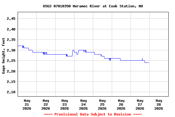
PROVISIONAL DATA SUBJECT TO REVISION
Click to hidestation-specific text
![]() Station operated in
cooperation with the Missouri
Department of Natural Resources.
Station operated in
cooperation with the Missouri
Department of Natural Resources.

Instantaneous-data availability statement
Boating safety tips are available from the
U.S. Coast Guard.
NOTE: During cold periods,
gage height and streamflow information may be adversely affected by
ice.
![]() Station operated in
cooperation with the Missouri
Department of Natural Resources.
Station operated in
cooperation with the Missouri
Department of Natural Resources.
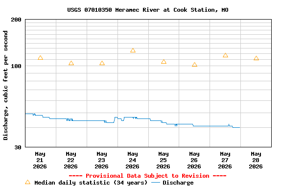
| Min (1977) | Most Recent Instantaneous Value May 28 | 25th percen- tile | Median | 75th percen- tile | Mean | Max (2016) |
|---|---|---|---|---|---|---|
| 14.0 | 40.0 | 57 | 112 | 160 | 162 | 1230 |
![]() U.S. Department of the Interior |
U.S. Geological Survey
U.S. Department of the Interior |
U.S. Geological Survey
Title: USGS Current Conditions for the Nation
URL:
Page Contact Information: Missouri Water Data Support Team
Page Last Modified: 2026-05-28 00:53:23 EDT
3.12 2.63 vaww02