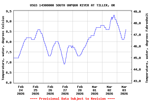
Most recent instantaneous value: 8.3 03-03-2026 12:30 PST
See this graph on the Monitoring Location Pages
Station operated in cooperation with Douglas County, the
Umpqua National Forest and the U.S. Geological Survey National
Streamflow Information Program (NSIP).
NOTE: River forecasts and additional data can be obtained at the
National Weather Service's Advanced Hydrologic Prediction Services web page.

NOTE: The most current shifted rating for this site can be found at USGS Rating Depot website.
| Boating safety tips |
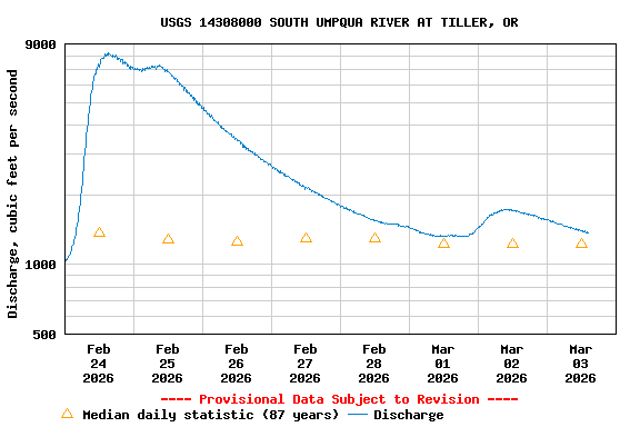
| Min (2005) | 25th percen- tile | Median | Most Recent Instantaneous Value Mar 3 | Mean | 75th percen- tile | Max (1972) |
|---|---|---|---|---|---|---|
| 239 | 768 | 1220 | 1380 | 1700 | 2040 | 17600 |
![]() U.S. Department of the Interior |
U.S. Geological Survey
U.S. Department of the Interior |
U.S. Geological Survey
Title: USGS Current Conditions for the Nation
URL:
Page Contact Information: Oregon Water Data Support Team
Page Last Modified: 2026-03-03 16:23:51 EST
4 3.37 vaww02