PROVISIONAL DATA SUBJECT TO REVISION
Click to hidestation-specific text
Funding for this site is provided by:
 Site Information
LOCATION.--Lat 43°48'29.3", long
73°27'28.4" referenced to North American Datum of
1983, Essex County, NY, Hydrologic Unit 04150408, on west shore
about 500 ft north of Hooper's dock at Rogers Rock, and 0.4
mi west of Baldwin.
DRAINAGE AREA.--233 mi². at outlet at Ticonderoga.
PERIOD OF RECORD.--July 1913 to current year (daily gage heights prior to October 2003, elevations thereafter).
REVISIONS HISTORY.--WDR NY-87-1: Datum.
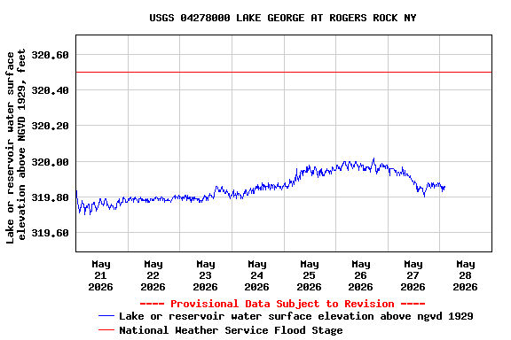
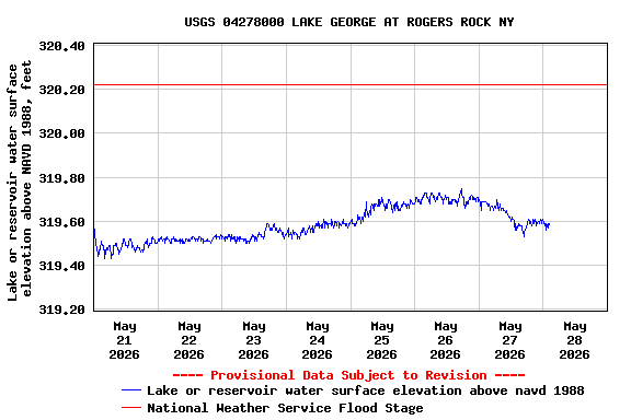
GAGE.--Water-stage recorder. Datum of gage is NGVD of 1929 (levels by New York State Department of Public Works). To convert elevations to NAVD of 1988, subtract 0.27 ft. Prior to Nov. 4, 1929, nonrecording gages at several sites within a half mile of present site. Nov. 4, 1929 to Sept. 26, 1936, nonrecording gage at present site. Prior to October 2003, at datum 316.06 ft higher.
REMARKS.--Elevation of lake regulated by floodgates at Ticonderoga. Prior to October 1974, lake was regulated by powerplant wheel gate and floodgates. Lake George has been controlled by a dam at its outlet for more than 100 years. Area of water surface is 44 mi².
EXTREMES FOR PERIOD OF RECORD.--Maximum elevation observed, 321.15 ft, present datum, Apr. 9, 1936; minimum elevation, 316.70 ft, present datum, Dec. 20, 1941.
DRAINAGE AREA.--233 mi². at outlet at Ticonderoga.
PERIOD OF RECORD.--July 1913 to current year (daily gage heights prior to October 2003, elevations thereafter).
REVISIONS HISTORY.--WDR NY-87-1: Datum.
GAGE.--Water-stage recorder. Datum of gage is NGVD of 1929 (levels by New York State Department of Public Works). To convert elevations to NAVD of 1988, subtract 0.27 ft. Prior to Nov. 4, 1929, nonrecording gages at several sites within a half mile of present site. Nov. 4, 1929 to Sept. 26, 1936, nonrecording gage at present site. Prior to October 2003, at datum 316.06 ft higher.
REMARKS.--Elevation of lake regulated by floodgates at Ticonderoga. Prior to October 1974, lake was regulated by powerplant wheel gate and floodgates. Lake George has been controlled by a dam at its outlet for more than 100 years. Area of water surface is 44 mi².
EXTREMES FOR PERIOD OF RECORD.--Maximum elevation observed, 321.15 ft, present datum, Apr. 9, 1936; minimum elevation, 316.70 ft, present datum, Dec. 20, 1941.
 WaterAlert – get an
email or text (SMS) alert based on your chosen threshold.
WaterAlert – get an
email or text (SMS) alert based on your chosen threshold.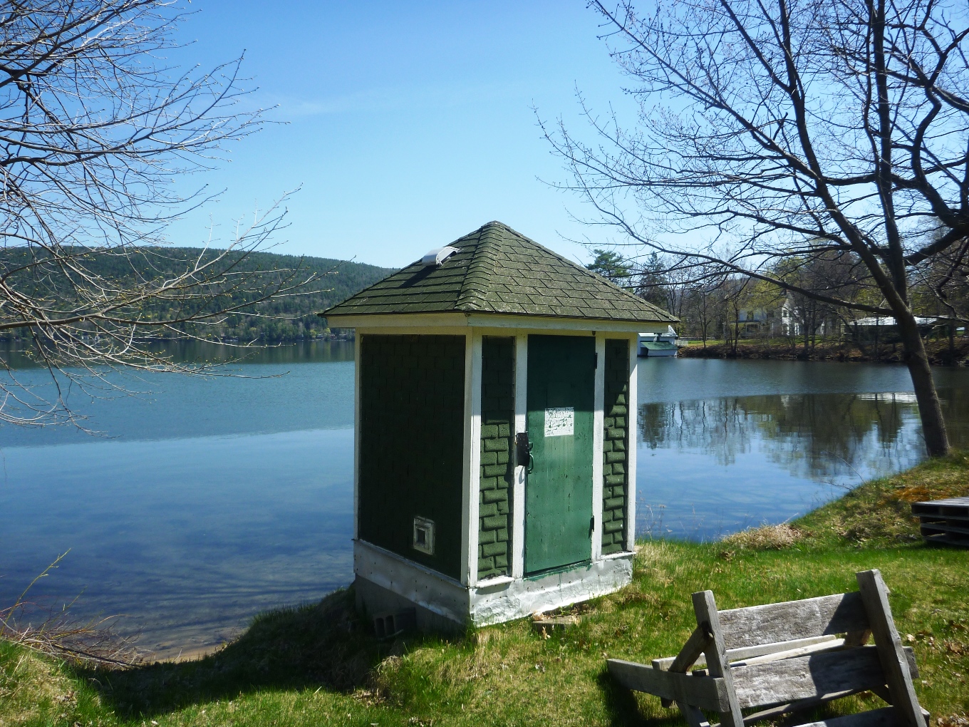 Station image
Summary of all available data for this site
Instantaneous-data availability statement