PROVISIONAL DATA SUBJECT TO REVISION
Click to hidestation-specific text
Funding for this site is provided by:
 STATION.--01531500 SUSQUEHANNA RIVER AT TOWANDA, PA
LOCATION.--Lat 41`45'55", long 76`26'28", Bradford County, Hydrologic Unit 02050106, on right bank at Bridge Street in Towanda, and 1.8 mi upstream from Towanda Creek.
DRAINAGE AREA.--7,797 square miles.
PERIOD OF RECORD.--October 1913 to current year. Gage-height records collected at same site from October 1892 to September 1913 are contained in reports of U.S. Weather Bureau.
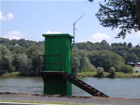
GAGE.--Water-stage recorder. Datum of gage is 693.70 ft above North American Vertical Datum of 1988. Prior to Oct. 18, 1938, non-recording gage at same site and datum. Satellite and landline telemetry at station. Prior to November 10, 2022, the datum of gage was erroneously reported as 694.38 ft above NGVD29.
COOPERATION.--Funding for the operation of this station is provided by the Pennsylvania Department of Environmental Protection and the U.S. Geological Survey.
REMARKS.--Flow slightly regulated by 7 flood-control reservoirs which have a combined capacity of 356,800 acre-ft.
GAGE HEIGHTS OF IMPORTANCE.--
Supplied by USGS: Maximum recordable gage height (stage sensor operational limit) - 34.1 ft; Data transmitter operational limit - 35.5 ft;
Supplied by NWS: Action stage-14 ft; Flood stage-16 ft, minor field flooding from both banks up and downstream of Towanda; Moderate flood stage-18 ft, basement flooding begins in the flats area near airport; Major flood stage-25.1 ft, the homes in the flats area of Towanda are inundated. Major flood damage begins.
Summary of all available data for this site
Instantaneous-data availability statement

