PROVISIONAL DATA SUBJECT TO REVISION
Click to hidestation-specific text
Funding for this site is provided by:
 STATION.--415323077451301 SUSQUEHANNA COUNTY, local
well number SQ61
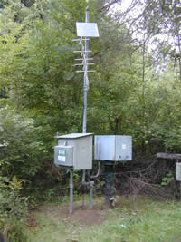
STATION.--415323077451301 SUSQUEHANNA COUNTY, local
well number SQ61LOCATION.--Lat 41`53'24.2", long 75`45'11.9", Hydrologic Unit 02050101, at State Game Land No. 175, and at New Milford.
OWNER.--U.S. Geological Survey.
AQUIFER.--Catskill Formation, Late Devonian age.
WELL CHARACTERISTICS.--Drilled observation well, diameter 6 in., depth 175 ft, cased to 80 ft, open hole.
INSTRUMENTATION.--Data collection platform with 60-minute recording interval. Satellite telemetry at station.
DATUM.--Elevation of land surface is 1,276 ft above North American Vertical Datum of 1988, from Lidar. Measuring point: Top of casing, 3.0 ft above land-surface datum.
REMARKS.--Daily maximum, minimum, and mean water levels since October 1994 are available from the District Office.
PERIOD OF RECORD.--July 1972 to October 2017.
COOPERATION.--Funding for the operation of this station is provided by the Pennsylvania Department of Environmental Protection and the U.S. Geological Survey.
Summary of all available data for this site
Instantaneous-data availability statement