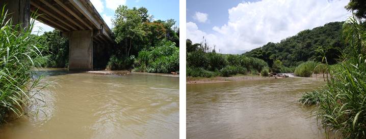
USGS 50144000 RIO GRANDE DE ANASCO NR SAN SEBASTIAN, PR

PROVISIONAL DATA SUBJECT TO REVISION

Click to hidestation-specific text

Click to go to the Junta de Calidad Ambiental de Puerto Rico web page

Station Drainage Area


Image of Rio Grande de Anasco near San Sebastian
Photos by USGS, Caribbean-Florida Water Science Center Hydrologic Technicians - San Juan.
This station managed by the Caribbean-Florida WSC - San Juan.

Available Parameters Available Period
  
2018-06-13  2022-11-23
1989-10-04  2026-05-28
2007-10-01  2026-05-28
2007-10-01  2026-05-28


 (7)
 

  -- or --


Summary of all available data for this site
Instantaneous-data availability statement

Precipitation, total, inches
 
-- Data temporarily unavailable for the time period specified --


Discharge, cubic feet per second

Most recent instantaneous value: 941 05-28-2026   19:00 AST
Graph of  Discharge, cubic feet per second

Add up to 2 more sites and replot for "Discharge, cubic feet per second"

?


Create presentation-quality / stand-alone graph.   Subscribe to WaterAlert      

See this graph on the Monitoring Location Pages


Daily discharge, cubic feet per second -- statistics for May 28 based on 63 water years of record more
Min
(1973)
25th
percen-
tile
Median Mean 75th
percen-
tile
Most Recent
Instantaneous
Value May 28
Max
(1980)
51.0 148 253 460 552 941 4810


Gage height, feet

Most recent instantaneous value: 4.12 05-28-2026   19:00 AST
Graph of  Gage height, feet

Add up to 2 more sites and replot for "Gage height, feet"

?


Create presentation-quality / stand-alone graph.   Subscribe to WaterAlert      

See this graph on the Monitoring Location Pages


Stream water level elevation, above Puerto Rico Datum of 2002, feet

Most recent instantaneous value: 109.57 05-28-2026   19:00 AST
Graph of  Stream water level elevation, above Puerto Rico Datum of 2002, feet

Add up to 2 more sites and replot for "Stream water level elevation, above Puerto Rico Datum of 2002, feet"

?


Create presentation-quality / stand-alone graph.   Subscribe to WaterAlert      

See this graph on the Monitoring Location Pages