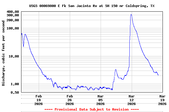
USGS 08069800 E Fk San Jacinto Rv at SH 150 nr Coldspring, TX

PROVISIONAL DATA SUBJECT TO REVISION

This station managed by the Houston Field Unit.

Available Parameters Available Period
  
2019-06-25  2026-01-30
2025-10-02  2026-01-30
2025-10-02  2026-01-30


 (31)
 

  -- or --


Summary of all available data for this site
Instantaneous-data availability statement


Discharge, cubic feet per second

Most recent instantaneous value: 2.07 01-30-2026   09:30 CST
Graph of  Discharge, cubic feet per second

Add up to 2 more sites and replot for "Discharge, cubic feet per second"

?


Create presentation-quality / stand-alone graph.   Subscribe to WaterAlert      

See this graph on the Monitoring Location Pages


Gage height, feet, [Primary Sensor]

Most recent instantaneous value: 194.30 01-30-2026   09:30 CST
Graph of  Gage height, feet, [Primary Sensor]

Add up to 2 more sites and replot for "Gage height, feet, [Primary Sensor]"

?


Create presentation-quality / stand-alone graph.   Subscribe to WaterAlert      

See this graph on the Monitoring Location Pages


Gage height, feet, [Secondary Sensor]

Most recent instantaneous value: 197.30 01-30-2026   09:30 CST
Graph of  Gage height, feet, [Secondary Sensor]

Add up to 2 more sites and replot for "Gage height, feet, [Secondary Sensor]"

?


Create presentation-quality / stand-alone graph.   Subscribe to WaterAlert      

See this graph on the Monitoring Location Pages