PROVISIONAL DATA SUBJECT TO REVISION
Click to hidestation-specific text
Funding for this site is provided by:
 STATION.--03022540 WOODCOCK CREEK AT BLOOMING
VALLEY, PA
STATION.--03022540 WOODCOCK CREEK AT BLOOMING
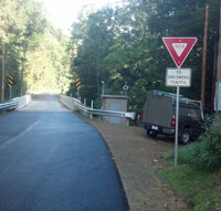
VALLEY, PALOCATION.--Lat 41`41'26", long 80`02'54", Crawford County, Hydrologic Unit 05010004, on left bank at upstream side of bridge, 0.7 mi northeast of Blooming Valley, and 3.4 mi upstream from Woodcock Creek Dam.
DRAINAGE AREA.--31.1 square miles.
PERIOD OF RECORD.--October 1974 to current year.
GAGE.--Water-stage recorder. Elevation of gage is 1,196.6 ft above North American Vertical Datum of 1988. Prior to April 4, 2023, the datum was erroneously reported as 1,200 ft above sea level, from topographic map. Satellite telemetry at station.
COOPERATION.--Funding for the operation of this station is provided by the U.S. Army Corps of Engineers, Pittsburgh District.
Summary of all available data for this site
Instantaneous-data availability statement


