PROVISIONAL DATA SUBJECT TO REVISION
Click to hidestation-specific text
 STATION.--03045000 LOYALHANNA CREEK AT KINGSTON,
PA
STATION.--03045000 LOYALHANNA CREEK AT KINGSTON,
PALOCATION.--Lat 40`17'33", long 79`20'27", Westmoreland County, Hydrologic Unit 05010008, on right bank 60 ft downstream from bridge on State Highway 217 at Kingston, 100 ft downstream from Miller Run, 1.9 mi upstream from Ninemile Run, and 3 mi southeast of Latrobe.
DRAINAGE AREA.--172 square miles.
PERIOD OF RECORD.--October 1939 to current year. Monthly discharge only October to December 1939, published in WSP 1305.
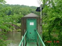
GAGE.--Water-stage recorder and crest-stage gage. Water-stage recorder and crest-stage gage. Datum of gage is 1012.78 ft above North American Vertical Datum of 1988. Prior to Oct 1, 1969, at datum 1.00 ft higher. Prior to December 21, 2023, the datum of gage was reported as 1,013.16 ft above National Geodetic Vertical Datum of 1929. Satellite telemetry at station.
COOPERATION.--Station established and maintained by the U.S. Geological Survey. Funding for the operation of this station provided by the U.S. Army Corps of Engineers, Pittsburgh District, the Pennsylvania Department of Environmental Protection and the U.S. Geological Survey.
REMARKS.--Flow regulated by Latrobe Reservoir, capacity, 3,670 acre-ft, and diversion works at Kingston.
GAGE HEIGHTS OF IMPORTANCE.-
Supplied by NWS: Action stage-13 ft; Flood stage-17 ft; Moderate flood stage-18 ft; Major flood stage-20 ft.
Summary of all available data for this site
Instantaneous-data availability statement


