PROVISIONAL DATA SUBJECT TO REVISION
Click to hidestation-specific text
Funding for this site is provided by:
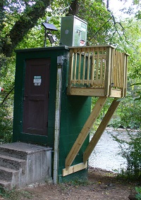 STATION.--01571500 YELLOW BREECHES CREEK NEAR CAMP
HILL, PA
STATION.--01571500 YELLOW BREECHES CREEK NEAR CAMP
HILL, PA LOCATION.--Lat 40`13'29", long 76`53'54", Cumberland County, Hydrologic Unit 02050305, on left bank 50 ft downstream from single-span highway bridge on Green Lane Drive, 1.0 mi southeast of Camp Hill, and 3.1 mi upstream from mouth.
DRAINAGE AREA.--213 square miles.
PERIOD OF RECORD.--March 1909 to December 1919, July 1954 to current year. Prior to January 1910 monthly discharge only, published in WSP 1302. Prior to June 1954, published as "at Olmsteds Mill".
GAGE.--Water-stage recorder and crest-stage gage. Datum of gage is 307.49 ft above National Geodetic Vertical Datum of 1929. March 1909 to December 1919, non-recording gage at site 50 ft upstream at same datum.
COOPERATION.--Station established and maintained by the U.S. Geological Survey. Funding for the operation of this station is provided by the Pennsylvania Department of Environmental Protection and the U.S. Geological Survey.
REMARKS.--There is diurnal regulation at low flow caused by operation of mill upstream.
GAGE HEIGHTS OF IMPORTANCE.-
Supplied by USGS: Data transmitter operational limit - 19.3 ft;
Supplied by NWS: Action stage-6 ft; Flood stage-7 ft, low lying areas in the Green Lane Farms development on the right bank of the Yellow Breeches Creek begin to flood; a mobile home park near Williams Grove is also affected; Moderate flood stage-9 ft, a number of homes in the Green Lane Farms development area affected; Cedar Cliff Drive on the left bank upstream from the bridge is inundated; Creekwood Drive has several feet of water on it and water is approaching homes; Major flood stage-13 ft, numerous homes along the entire length of Yellow Breeches Creek are affected by high water levels.
Summary of all available data for this site
Instantaneous-data availability statement

