PROVISIONAL DATA SUBJECT TO REVISION
Click to hidestation-specific text
Funding for this site is provided by:
 STATION.--03106300 MUDDY CREEK NEAR PORTERSVILLE,
PA
STATION.--03106300 MUDDY CREEK NEAR PORTERSVILLE,
PALOCATION.--Lat 40`57'48", long 80`07'29", Butler County, Hydrologic Unit 05030105, on right bank 3,5000 ft downstream from Lake Arthur Dam, 500 ft west of State Road 4017, and 3 mi north of Portersville.
DRAINAGE AREA.--51.5 square miles.
PERIOD OF RECORD.--March 1963 to September 1993, July 1994 to current year.
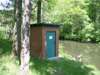
GAGE.--Water-stage recorder. Datum of gage is 1153.9 ft above North American Vertical Datum of 1988 (from GNSS survey). Prior to Apr. 8, 1963 non-recording gage at site 500 ft upstream at different datum. Apr. 8 to May 1, 1963, non-recording gage and May 2, 1963 to Sept. 30, 1980, water-stage recorder at site 1,500 ft upstream at datum 0.9 ft higher. October 1, 1980 to October 19, 2021, gage 2,500 ft upstream at datum 0.2 ft higher. Prior to February 21, 2024, the datum of gage for the period of October 1, 1980 to October 19, 2021 was erroneously reported as 1160.91 ft above National Geodetic Vertical Datum of 1929 (NGVD29). The datum of gage for the period after October 19, 2021 was erroneously reported as 1161 ft above NGVD29. Satellite telemetry at station.1,161 ft above National Geodetic Vertical Datum of 1929 (Digital Elevation Model)
COOPERATION.--Station established and maintained by the U.S. Geological Survey. Funding for the operation of this station is provided by the Pennsylvania Department of Environmental Protection and the U.S. Geological Survey.
REMARKS.--Some regulation from October 1966 to May 1969 and completely regulated thereafter by Lake Arthur (Station 03106280) 3,500 ft upstream.
Summary of all available data for this site
Instantaneous-data availability statement


