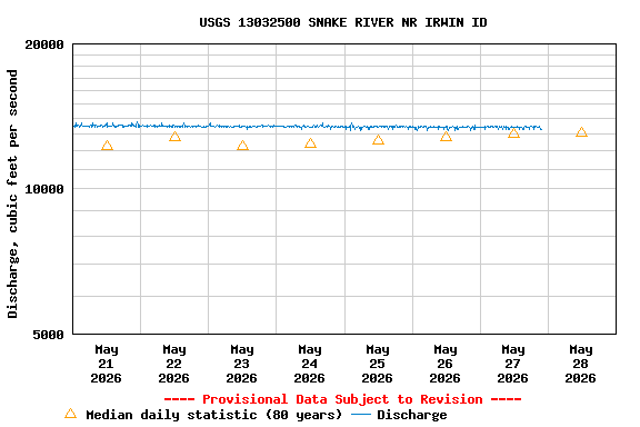
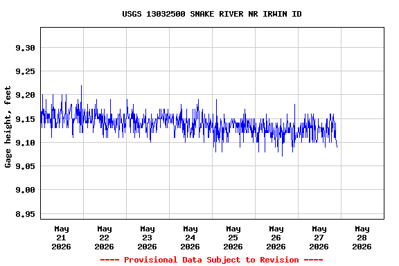
LOCATION.--Lat 43° 21'03", long 111° 13'08"
(NAD83), in NE1/4 NE1/4 sec.7, T.1 S., R.45 E., Bonneville County,
Hydrologic Unit 17040104, Palisades Dam quad., on right bank at U.S.
Bureau of Reclamation headquarters, 1.5 mi downstream from Palisades
Dam, 2 mi upstream from Palisades Creek, 5 mi southeast of Irwin, and
at mile 900.2.
DRAINAGE AREA.--5,225 mi².
PERIOD OF RECORD.--March to October 1935, April to October 1936,
May 1949 to current year. Records for station "at Calamity
Point, near Irwin" April to August 1934, April to October 1935,
April to October 1936, March 1939 to September 1941 are equivalent to
those for this station.
REVISED RECORDS.--WSP 1217: Drainage area.
GAGE.--Water-stage recorder. Datum of gage is 5,353.00 ft above
NGVD of 1929 (levels by U.S. Bureau of Reclamation). Mar. 30, 1935 to
Oct. 31, 1936, water-stage recorder at site 3.5 mi downstream at
different datum. May 1, 1949 to Mar. 22, 1950, nonrecording gage at
site 1,100 ft downstream at datum 1.9 ft higher.
REMARKS.--Flow regulated by Jackson Lake and Palisades Reservoir.
Diversion from tributaries above station for irrigation in Wyoming
and Idaho of about 95,300 acres (1966 determination).
EXTREMES FOR PERIOD OF RECORD.--Maximum discharge, 40,400 ft³/s
June 19-22, 1997; maximum gage height, 15.25 ft, June 19, 20, 1997;
minimum discharge, 19 ft³/s Nov. 8, 1956, result of discharge
measurement.
EXTREMES OUTSIDE PERIOD OF RECORD.--Flood in early June 1894
probably was higher than that of June 19-22, 1997.