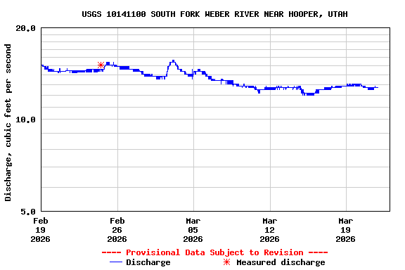
USGS 10141100 SOUTH FORK WEBER RIVER NEAR HOOPER, UTAH

PROVISIONAL DATA SUBJECT TO REVISION

This station managed by the Salt Lake City Field Office.

Available Parameters Available Period
  
2024-12-06  2025-12-15
2024-12-06  2025-12-15
2024-12-06  2025-12-15


 (31)
 

  -- or --


Summary of all available data for this site
Instantaneous-data availability statement


Discharge, cubic feet per second

Most recent instantaneous value: 17.9 12-15-2025   05:15 MST
Graph of  Discharge, cubic feet per second

Add up to 2 more sites and replot for "Discharge, cubic feet per second"

?


Create presentation-quality / stand-alone graph.   Subscribe to WaterAlert      

See this graph on the Monitoring Location Pages


Gage height, feet

Most recent instantaneous value: 3.12 12-15-2025   05:15 MST
Graph of  Gage height, feet

Add up to 2 more sites and replot for "Gage height, feet"

?


Create presentation-quality / stand-alone graph.   Subscribe to WaterAlert      

See this graph on the Monitoring Location Pages


Mean water velocity for discharge computation, feet per second

Most recent instantaneous value: 0.05 12-15-2025   05:15 MST
Graph of  Mean water velocity for discharge computation, feet per second

Add up to 2 more sites and replot for "Mean water velocity for discharge computation, feet per second"

?


Create presentation-quality / stand-alone graph.   Subscribe to WaterAlert      

See this graph on the Monitoring Location Pages