USGS 12459000 WENATCHEE RIVER AT PESHASTIN, WA

PROVISIONAL DATA SUBJECT TO REVISION

Click to hidestation-specific text
Arrow

Additional Data and Information.-- Latest shifted rating.

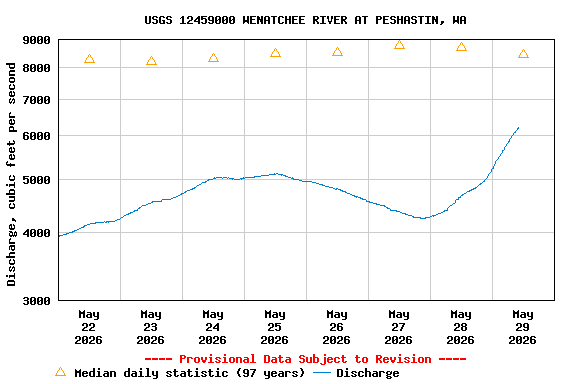
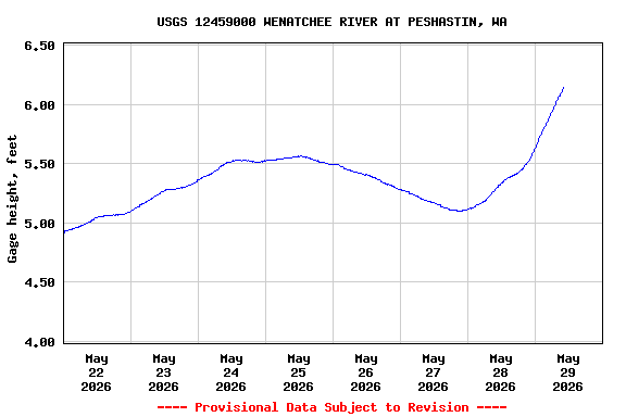
Flood Stage.--The National Weather Service Flood Stage for this station is 13.0 feet.

Funding for this site is provided by the cooperators / programs below:

Station Notes
Arrow
ice
This station is affected by ice during extreme cold weather periods. A description of the types of ice affecting rivers can be download here.

gage
The National Weather Service maintains the precipitation equipment.

Boating safety tips

This station managed by the Upper Columbia Field Office (Spokane).

Available Parameters Available Period
  
1989-11-30  2024-03-19
2007-10-01  2024-03-19


 (7)
 

  -- or --


Summary of all available data for this site
Instantaneous-data availability statement


Discharge, cubic feet per second

Most recent instantaneous value: 1950 03-19-2024   03:15 PDT
Graph of  Discharge, cubic feet per second

Add up to 2 more sites and replot for "Discharge, cubic feet per second"

?


Create presentation-quality / stand-alone graph.   Subscribe to WaterAlert      

See this graph on the Monitoring Location Pages


Daily discharge, cubic feet per second -- statistics for Mar 19 based on 95 water years of record more
Min
(2023)
25th
percen-
tile
Median Most Recent
Instantaneous
Value Mar 19
Mean 75th
percen-
tile
Max
(1972)
701 1080 1530 1950 1990 2420 8730


Gage height, feet

Most recent instantaneous value: 3.53 03-19-2024   03:15 PDT
Graph of  Gage height, feet

Add up to 2 more sites and replot for "Gage height, feet"

?


Create presentation-quality / stand-alone graph.   Subscribe to WaterAlert      

See this graph on the Monitoring Location Pages