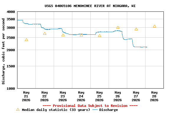
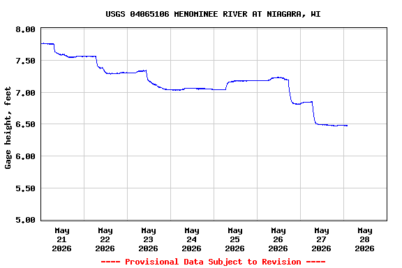
PROVISIONAL DATA SUBJECT TO REVISION
LOCATION.--Lat 45°46'04", long 87°58'50", in NE 1/4 NE 1/4 sec.15, T.38 N., R.20 E., Marinette County, Hydrologic Unit 04030108, on right bank 0.7 mi downstream from Little Quinnesec Falls Dam, at Niagara.
DRAINAGE AREA.--2,470 square miles.
PERIOD OF RECORD.--October 1992 to present.
GAGE.--Water-stage recorder. Elevation of gage is 867.42 ft. NAVD88.
REMARKS.--Flow regulated by powerplants, by Michigamme Reservoir, capacity 119,950 acre-ft, by Peavy Pond, capacity 33,860 acre-ft, on Michigamme River, and by smaller reservoirs upstream of gage. Gage-height telemeter at station.
Discharge values displayed at this site are often affected by ice in the winter, which leads to increased uncertainty. Click HERE for more info.
Additional Information:
 National Weather Service Flood Forecast Page
OPERATED IN COOPERATION WITH:
Federal Energy Regulatory Commission Licensee:
| Boating safety tips |
Summary of all available data for this site
Instantaneous-data availability statement