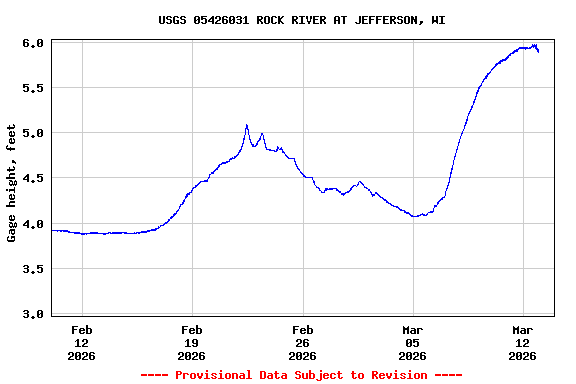
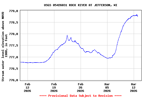
USGS 05426031 ROCK RIVER AT JEFFERSON, WI

PROVISIONAL DATA SUBJECT TO REVISION

Available Parameters Available Period
  
1986-10-01  1994-09-30
2022-04-21  2025-12-13
2022-12-13  2025-12-13


 (31)
 

  -- or --


Summary of all available data for this site
Instantaneous-data availability statement

Discharge, cubic feet per second
 
-- Data temporarily unavailable for the time period specified --


Gage height, feet

Most recent instantaneous value: 3.82 12-13-2025   06:00 CST
Graph of  Gage height, feet

Add up to 2 more sites and replot for "Gage height, feet"

?


Create presentation-quality / stand-alone graph.   Subscribe to WaterAlert      

See this graph on the Monitoring Location Pages


Stream water level elevation above NAVD 1988, in feet

Most recent instantaneous value: 776.68 12-13-2025   06:00 CST
Graph of  Stream water level elevation above NAVD 1988, in feet

Add up to 2 more sites and replot for "Stream water level elevation above NAVD 1988, in feet"

?


Create presentation-quality / stand-alone graph.   Subscribe to WaterAlert      

See this graph on the Monitoring Location Pages