
Decommissioning of legacy WMA water-quality data applications
A post explaining and answering questions about decommissioning three legacy water applications
What are you decommissioning?
As the USGS Water Mission Area (WMA) undertakes modernizing data delivery as part of implementation of the U.S. Geological Survey Water Science Strategy (Circular 1382-G; https://doi.org/10.3133/cir1383G), resources will be directed away from legacy applications to new development and delivery mechanisms. In 2020, several WMA web applications are reaching end-of-life, are subject to critical vulnerabilities, and/or are subject to increased licensing fees. In order to continue operations, significant investment would be required to upgrade existing systems and remain in compliance. Three applications that were identified to be shut down (decommissioned) in the immediate future are Watershed Regressions for Pesticides, The Sediment Data Portal, and Tracking Water Quality of the Nations Rivers.
Watershed Regressions for Pesticides
The WARP application displays data from WARP models for pesticides, which were developed using linear regression methods to establish quantitative linkages between pesticide concentrations and a variety of human-related and natural factors that affect pesticides in streams. Measured pesticide concentrations, together with the associated values of the explanatory variables for the sampling sites, comprise the model-development data. The models used to create maps and graphs are the models for the annual mean and annual maximum moving averages (4-, 21-, 30-, 60-, and 90-day durations), based on Stone and others (2013). For each of these annual concentration statistics, the models can be used to estimate the value for a particular stream, including confidence bounds on the estimate, or the probability that a particular value will be exceeded, such as a water-quality benchmark.
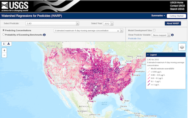
A screenshot of Watershed Regressions for Pesticides (WARP) showing predicted CONUS-wide concentrations over an estimated maximum 4-day moving-average for the pesticide 2,4D in the year 2012.
Sediment Data Portal
The Sediment Data Portal displays the location of sites in which discrete and (or) daily suspended sediment data have been collected in the United States. The U.S. Geological Survey National Water Information System (NWIS) is the original source for all suspended-sediment data provided in the portal. Daily suspended-sediment data are retrieved directly from NWIS; discrete suspended-sediment were retrieved from NWIS in July 2017 and have been screened to only those data thought to best represent particular sampling sites and to sites with data potentially adequate to compare among sites or compute loads.
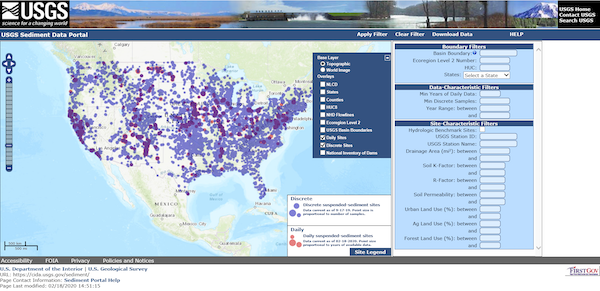
A screenshot of the Sediment Data Portal showing both daily and discrete suspended sediment sites for CONUS.
Tracking Water Quality of the Nation’s Rivers and Streams
The USGS National Water-Quality Assessment (NAWQA) Project is characterized the status and trends of the Nation’s surface-water quality through a National Water Quality Network. This website provides data on national ambient water-quality conditions. The data are reported systematically and updated annually. The Project has the acronym NAR, which stands for NAWQA Annual Reports. Annual Reports will continue to be published after the decommissioning of this product.
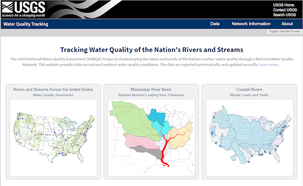
A screenshot of Tracking Water Quality of the Nation's Rivers and Streams showing three options: Rivers and Streams Across the United States (left), Mississippi River Basin (center), and Coastal Rivers (right).
What is the timeline?
- Watershed Regressions for Pesticides will be decommissioned on April 30, 2020.
- The Sediment Data Portal will be decommissioned on May 29, 2020.
- Tracking Water Quality of the Nations Rivers will be decommissioned on July 15, 2020. Users will be rerouted to a replacement for this website (not yet available).
Where can I find the data after the applications are turned off?
Continued, long term access to web application data will be provided viaalternative data repositories such as Science Base or NWISWeb.
What are the next steps?
Some functionality currently provided in these web applications will be brought forward in Water Data for the Nation in the future.
What about me?
We want to hear users’ feedback on how they access and use water quality data. In order to plan for future water quality data and information delivery, a listening session for water quality data users and users of these applications will be held in April 2020.
Please stay tuned for additional information and contact gs-w-iow_po_team@usgs.gov with questions or to request more information on the upcoming listening sessions.
Categories:
Keywords:
Related Posts
#5NewThings
August 21, 2020
The Water Resources Mission Area is spotlighting five newly available features on our next-gen monitoring location pages this week! To compliment this blog post, we will show off our work on Instagram and Twitter, using the hashtag #5NewThings.
Water Quality Data Delivery Listening Sessions
July 28, 2020
Water Quality Data Delivery Listening Sessions Starting on August 3, 2020, the WDFN Team will be conducting a month of activities aimed at gathering input from both internal and external users to help guide development activities related to water-quality data delivery.
Decommissioning of the National Water Census - Data Portal
July 22, 2020
What are you decommissioning? As the USGS Water Mission Area (WMA) undertakes modernizing data delivery as part of implementation of the U.S. Geological Survey Water Science Strategy (Circular 1382-G), resources will be directed away from legacy applications to new development and delivery mechanisms.
Release Notes for July 21st, 2020
July 21, 2020
What have we been up to? Pubs Warehouse moved to the Cloud Behind the scenes work New features and tools Pubs Warehouse on the Cloud The Water Data for the Nation team is the primary development team for another high profile application, the USGS Publications Warehouse.
Doing user research to design the next-gen WDFN
July 17, 2020
The USGS Water Resources Mission Area (WMA) is striving to make our water data easier to access for our users. This involves stepping back and reviewing how users currently use waterdata.