
FAQ for Next Generation Monitoring Location Pages
All your commonly asked questions about the modernization of NWISWeb's real-time pages to WDFN's Next Generation Monitoring Location pages.
Last updated May 3rd, 2022
For ease of use, we recommend you CTRL+F (for Windows) or Command+F (for Mac) to search this page for the section that relates to your question.
The old website has served the public well, but it is 25 years old—that’s about 80% of the entire history of the World Wide Web! Over the last 10 years, we have observed declining user satisfaction with the old website; novice users in particular tell us the legacy pages are challenging to understand and not intuitive to use. Under the hood, the programming has become outdated and has become difficult to maintain and it is practically impossible to add new features. The best way for us to serve the public well into the future is to modernize our pages.
We know a multi-station or multi-parameter feature is highly requested from users. We’re addressing this by gathering more use-cases and undertaking a discovery project in 2022. We’re excited for this feature to be released, but each feature takes time to produce and we’re working on many features, so we’ve committed to addressing this before the next step in the decommission process which we anticipate will occur in September 2022.
The NextGen pages will continue to evolve over time, adding new features and incorporating key information available on legacy pages. Current-condition real-time water data account for over 90% of our water-data web page requests, but we understand that other types of water data are very important to some users. These other forms of water data available in legacy pages—daily values, statewide streamflow tables, annual-peak values, and many more—will be evaluated for modernization in the coming years. Eventually the entire old legacy website will be turned off (decommissioned) but that will not happen until we are able to evaluate the importance of all water data currently available on legacy pages.
Interactive: Users, #WeHearYou – you wanted an interactive hydrograph, so we made that a top priority in the early development of the new pages. Users wanted to view the data on their mobile devices, and they wanted to interact with many elements of the graph like data shown, time span, and calculated median data.
Fast load time: A single interactive hydrograph is fast for the default 7-day view, but takes some time to load data as users select longer time spans. Based on current technology, we do not advise that a single page provide interactive hydrographs for all possible parameters, as it would not allow for fast loading on mobile devices. Although there are multiple graphs on the legacy pages, those are not interactive, and the technology difference is vast between the two styles of use.
Improved usability: During user testing we have found that users are confident in interacting with the hydrograph. Our usage metrics show that people use the interactive elements commonly and intuitively.
Future plans: We will continue to build out the interactive elements to allow multiple parameters to show simultaneously to provide a more robust experience for our users.
We have an easy way for you to customize your default parameter: bookmarking a page that shows discharge will show discharge again when that bookmark is revisited. We acknowledge the value of the other common parameter: volumetric streamflow (discharge) data. But at this time, feedback from the general public has been that gage height is preferred as the default parameter. Read more about the importance of gage height in our recent blog post.
Eventually, yes. Starting in October 2021 the legacy pages will no longer be the preferred view the public sees and search engines index. In March 2022, the Next Generation pages will become the default view and legacy pages will redirect to them. In January 2023 the legacy real-time current-condition pages will be decommissioned entirely.
Yes, they will remain viewable until their full January 2023 decommissioning. A special link on a NextGen page will let users reach these pages after redirecting begins. Note that after redirects begin, search engines will show legacy pages less and less in search results.
Yes. When possible, old URLs will redirect to a modernized, relevant alternative. When not possible, we plan to redirect to a web page explaining where to find various types of water data.
No, only the current-condition real-time pages. All other pages like daily values, statewide streamflow, Water-Year Summary, will be evaluated and decommissioned on a case-by-case basis, leading to an eventual full decommission. But that date is not yet known.
They were excellent for their time, much like a classic car represents the best of its era. We know there is room for improvement to meet changing standards and broad user needs, which is why we are releasing NextGen pages.
The redesign of real-time pages is based on several sources of information: a comprehensive inventory of existing NWISWeb functionality, customization of pages by USGS Water Science Centers, user surveys, web analytics, and the USGS Water Science Strategy. The new user interface is more accessible for all users—especially new ones. The re-design puts data at the top of the page, is mobile ready, uses human-readable names and terms, and is built for integration with other applications and data sources. The codebase and infrastructures are optimized for performance and up-time, and instrumented with auditing tools and vulnerability detection. Data integrity remains paramount. Finally, an iterative software development process will engage all users early in the development process and produce frequent, meaningful improvements.
Yes, for several reasons but let’s consider the principal one: we are still modernizing old systems and then turning them off! So things like discrete water-quality data, annual-peaks data, daily-values data, and more must be fairly represented in modernized pages. We will be sharing our roadmap and backlog of feature requests so you can understand what might be coming.
It depends. For real-time current-condition pages, the answer was and is “Yes!” For other capabilities, we are evaluating them on a module-by-module basis. Features may be modernized, may be discontinued, or in some cases reconceived in a very different way based on what has been learned from 25 years of water data on the web.
We are working on publishing a roadmap and/or feature backlog for you to view for yourself. As of late 2021, examples of important features considered for modernization are: discrete water-quality data, imagery such as cameras, multiple parameters on one plot, daily-values data, annual-peaks data, and downloadable plots. If usability tests and analytics indicate a feature was not used or was difficult to understand, we might not keep it.
The WDFN team in Water Mission Area is collecting these use cases and plan to undertake a “discovery” research project on these in FY22. We understand cooperators fund networks of gages (not individual gages), but we also must ensure members of the public derive value from these types of reports.
Yes, we plan to develop a new explore, filter, and download user interface in FY22. We also know that external search engines are the source of most web traffic to real-time pages, so we will be making the redesigned pages as “crawlable” and “friendly” to search engine robots as possible.
Yes, more than ever. We are here to listen. Constructive feedback is intrinsic to our design process. By users’ feedback and through their actions (tracked by web analytics), we continue to optimize design and functionality.
New pages have a button on the footer labeled “Questions or Comments.” Submission here go directly to our product management team.
Not at this time. With limited resources, we are focused on building the best mobile-first website we can. There are no plans to build platform-specific apps at this time.
Right now, presentation-quality graphs are not available on NextGen pages. We’ve gotten a few other users requesting the continuation of presentation-quality style graphs, and we’d love to help. Can you help us help you? Send us an email and tell us what you use the graphs for, and how you define a presentation-quality style graph. We’ll use your feedback to inform future work on presentation-quality graphs through Water Data for the Nation.
Great, we’d love to have you! What kind of tester do you want to be? Do you view water data in a web browser? Or do you write software or code that call our services or APIs? Or maybe some of both? We need usability testers for all user types - from the casual user checking status of a local stream or lake, to users routinely accessing our data and information programmatically. Send us an email at WDFN_usabilitytesting@usgs.gov .
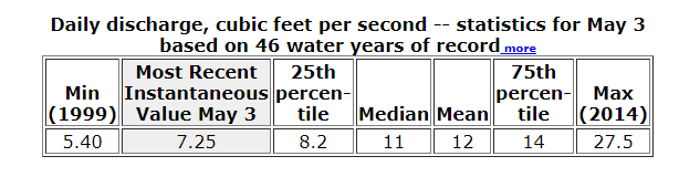
Daily statistics in table format as it appears on NWISWeb Legacy Current-Conditions Real-time pages.
But USGS does not provide forecasting data, the National Weather Service (NWS) does, so on some of our Legacy pages, Water Science Centers offer a link to the forecasting information provided by the National Weather Service’s Advanced Hydrologic Prediction Service .
On our Next Generation Monitoring Location Pages, we do not have a link to the NWS’s flood forecasting pages, however, in an attempt to meet user needs, we are researching if it’s possible for us to provide that forecasting information on the NextGen pages.
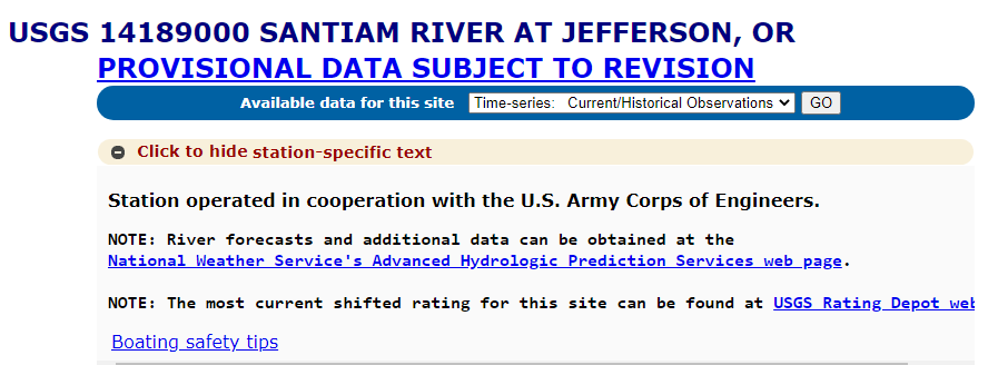
Example of the customized text from a Water Science Center that offers a link to the National Weather Service’s Advanced Hydrologic Prediction Services page.
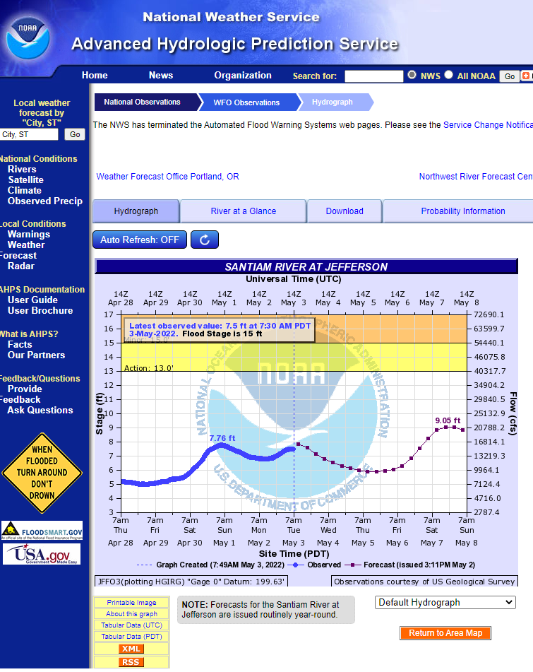
Example of the National Weather Service’s Advanced Hydrologic Prediction Services page for a particular monitoring location.
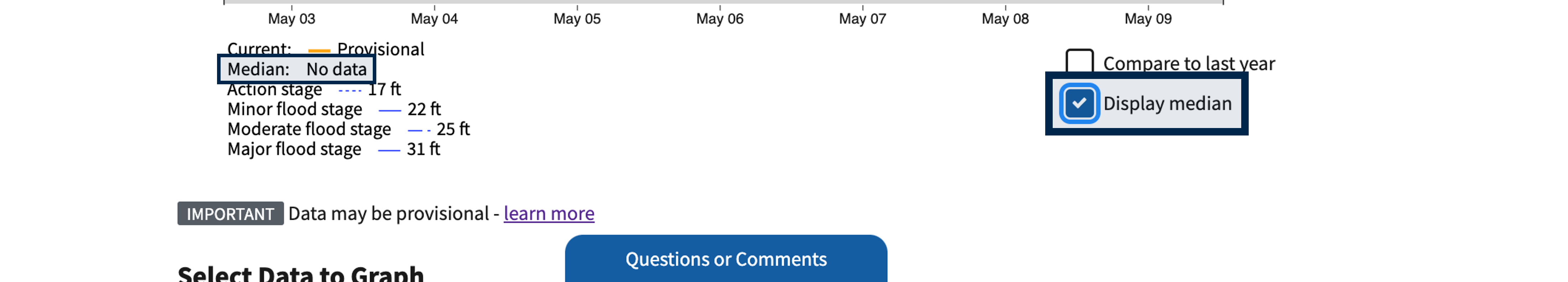
If you check the ‘display median’ check box for a parameter for which we do not publish a daily value statistic, it will display ’no data’.
We don’t always have median data available for one of two reasons:
- We have no median data recorded for that parameter at that particular monitoring location because it has not been calculated or
- We can’t offer median data for that specific parameter because it goes against best data management practices
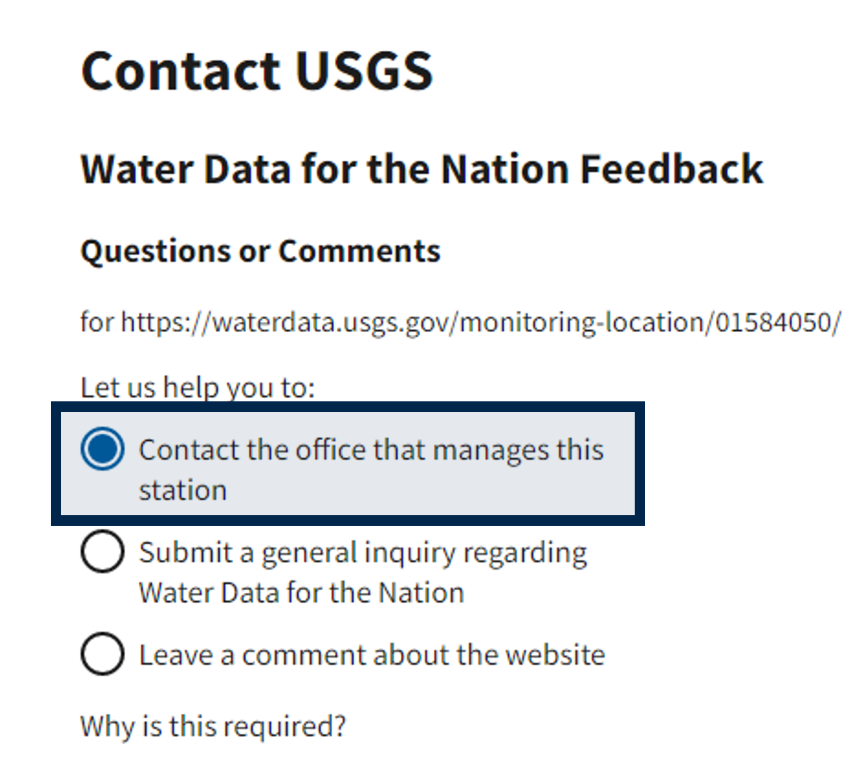
If you want the median data for a specific parameter at a specific location, click the ‘Questions or Comments’ button on any monitoring location page (see previous screenshot) and select the ‘Contact the office that manages this station’ option to talk to the Water Science Center associated with that monitoring location.
Is your question not answered here? Let us know by sending us an email at wdfn@usgs.gov .
Categories:
Related Posts
Modernizing How You Access Water Data | Webinar on Oct 13 | Recording Available
October 1, 2021
Missed the webinar? Watch the recording The recording of this webinar can be viewed on the USGS website or on the USGS YouTube channel . Let us know your thoughts!
How to Use Next Generation Monitoring Location Pages
September 8, 2021
Last updated April 7th, 2022 Welcome to our how-to guide for WDFN's Next Generation Monitoring Location Pages Looking for guidance on how to use the NextGen pages?
Next Generation Monitoring Location Pages Go Live Soon!
August 17, 2021
Last updated October 21, 2021 To learn more about these changes, watch the recording of our October 2021 public webinar. What are Monitoring Location Pages? Monitoring location pages are web pages that the USGS Water Mission Area offers to display important water data like discharge (also referred to as streamflow), gage height, precipitation, water-levels, temperature, etc.
The WDFN tech stack
April 14, 2022
The goal of this post is to give a technical reader an idea of what technologies the Water Data for the Nation (WDFN) team uses, because it is both varied and ever changing.
Technology Cluster Hire: Usability Specialist and DevOps Positions
April 11, 2022
USGS Water Mission Area 2022 Cluster Hires (updated 4/19/2022) The U.S. Geological Survey Water Mission Area is hiring multiple Term Information Technology (IT) Specialist positions in Usability Research and Development-Operations (DevOps) for enterprise data delivery systems.