
Progress Toward a Reference Hydrologic Geospatial Fabric for the United States
This post provides background information for those interested in engaging in use and development of the National Hydrologic Geospatial Fabric (NHGF) Reference and Derived Hydrofabrics provisional data release and the Network Linked Data Index , a search engine built to leverage the NHGF reference hydrofabric. It introduces key terminology used in documentation of this in-development dataset which is part of the U.S. Geological Survey’s contribution to the Internet of Water and interagency continental-scale hydrologic modeling initiatives. The material summarized here is not fundamentally new. It is based on a body of prior research and development including:
- An Analysis of Water Data Systems to Inform the Open Water Data Initiative
- Internet of Water: Sharing and Integrating Water Data for Sustainability
- Environmental Linked Features Interoperability Experiment
- Making the Digital Water Flow
- NHDPlus (National Hydrography Dataset Plus)
- OGC WaterML2: Part 3 - Surface Hydrology Features (HY_Features) Conceptual Model
- Mainstems: A logical data model implementing mainstem and drainage basin feature types based on WaterML2 Part 3: HY Features concepts
Terms and Definitions
Some terms used in this post come from the OGC WaterML2: Part 3 - Surface Hydrology Features (HY_Features) - Conceptual Model . The following are important definitions for terms used later in this post. “Quoted” text is from the HY_Features specification.
- Catchment: “A physiographic unit where hydrologic processes take place.” An HY_Features catchment is a more wholistic and conceptual feature than a polygon. It is represented by multiple partial conceptual realizations: divide, flowpath, area, and hydronetwork.
- Waterbody: “Mass of water distinct from other masses of water” The HY_Features concept of waterbody is inclusive of flowing and non flowing waters.
- Hydrologic Location: “Any location of hydrologic significance located ‘on’ a hydrologic network that is a hydrology-specific realization of a hydrologic nexus.” An HY_Features hydrologic location is a location that can be thought of as the outlet of a watershed.
- Index / indexing: Not defined in HY_Features but important here, an index of hydrologic data describes what hydrologic feature another feature is associated with. Typically, this is a link to a commonly used dataset. For example, an index could relate monitoring locations to rivers they monitor allowing a person to lookup the location of a monitoring location on the river network like a term in the index of a book. Indexing is the act of building specific associations between features.
Hydrofabrics
A hydrologic geospatial fabric, or hydrofabric, is a dataset containing a network of connected representations of rivers, lakes, and catchments. Figure 1 is a graphical depiction of the elements of a hydrofabric. In practice, a hydrofabric is purpose-built, meaning that the choices about the representation of rivers, lakes, and catchments with spatial and attribute information are for a specific purpose. For example, a hydrofabric meant to support hydrologic modeling will include different content than a hydrofabric meant to support hydrodynamic or flood inundation modeling. While the connectivity of rivers is the same, a hydrologic model will emphasize rainfall runoff model needs and a hydrodynamic model will emphasize channel hydraulics needs. The potential diversity of hydrofabrics reflect the diversity of integrated water resources problems. Regardless of purpose, the key function of a hydrofabric is to connect model applications to relevant information such as observations and/or important infrastructure.
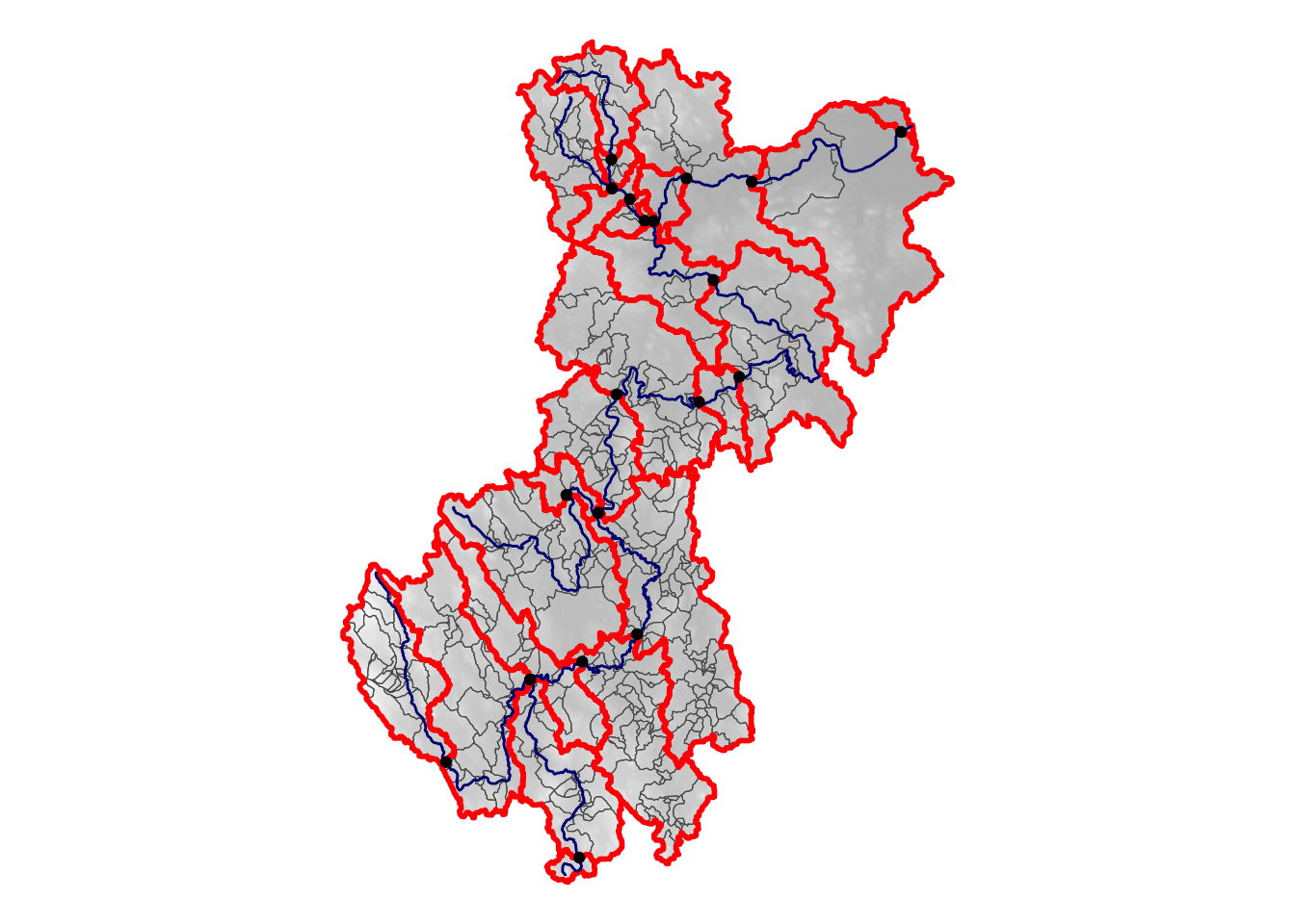
Figure 1: A hydrologic geospatial fabric is a network of geospatial data that represent rivers, lakes, and catchments.
Every observation of environmental phenomena characterizes some entity. The international community data standard “Observations and Measurements” formalizes the relationship between three distinct pieces of information: an observation act, the results of an observation, and the feature of interest of an observation. A model prediction can be thought of as a virtual observation which has an associated feature of interest and results. A new, not yet released, version of Observations and Measurements introduces a distinction between a “proximate” feature of interest and an “ultimate” feature of interest, where proximate is often a sensor and ultimate is an environmental feature such as a water body. In these terms, a hydrofabric provides a system of connected ultimate features of interest (water bodies and catchments) to which we can index proximate features of interest (monitoring locations). For applications like the Network Linked Data Index, a search engine for hydrologic data, hydrofabrics are useful for relating observational data to water bodies and catchments. Use of a shared hydrofabric is important to enable integration of model applications that involve networks of waterbodies or catchments.
A “reference hydrofabric” is a special type of hydrofabric that fulfills a unique purpose in data integration and model hydrofabric development. A reference hydrofabric is used for indexing observational data to a network of common features (Figure 2) and is used as an input to model fabric development. Two key characteristics are: 1) as simple as possible but no simpler geometric representations of water bodies and catchments and 2) use of identifiers that are persistent despite refinement and evolution of representations over time. These characteristics are useful for indexing for performance and durability of links in an index. Using a single reference fabric as a source for purpose-built model fabrics ensures that they have a well-defined relationship and the model applications that use them are interoperable.
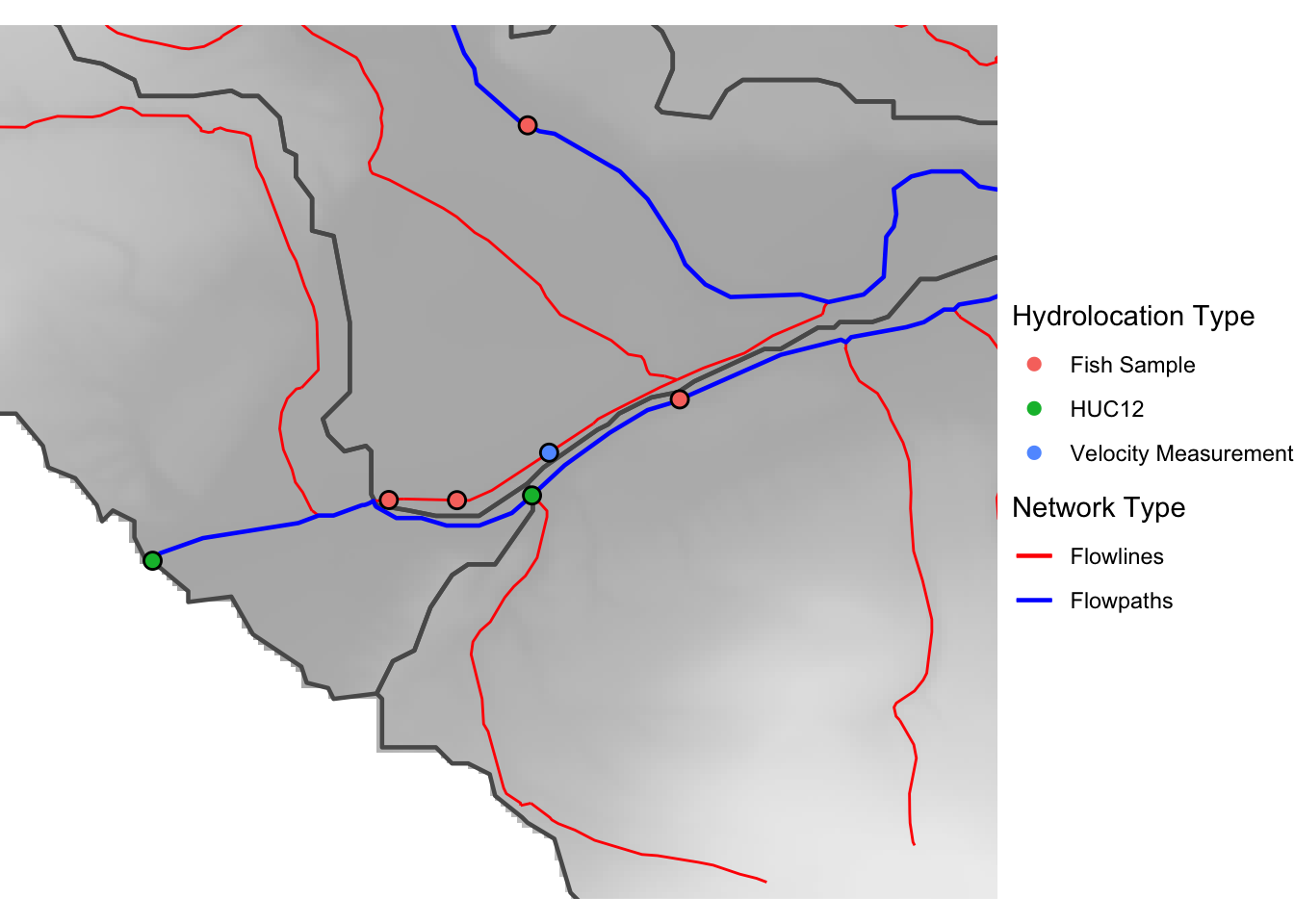
Figure 2: A reference hydrologic geospatial fabric is a network of geospatial data that other data can be linked to and other datasets based on.
Hydrologic Data Indexing and Integration
Indexing (establishing links) and integration (combining) require that persistence and forward compatibility is the priority for a reference hydrofabric. In other words, once a link has been established, that link should be durable and trustworthy. Practically, this requires using a system of identifiers that are intentionally persistent and demands hydrologic meaning of identified water bodies or catchments is not altered as representations of them evolve. The NHGF Reference Hydrofabric meets these needs through use of the new Mainstems data model (Figure 3) and outcomes of the Environmental Linked Features Interoperability Experiments which specify a minimally sufficient data model and intentionally persistent web-identification architecture respectively. To date, creation of new identifiers for mainstem rivers has been purposefully conservative and limited to only named rivers and those over 200 square kilometers total drainage area. As progress is made with high resolution hydrography in the Mainstems workflow , rivers and drainage basins with identifiers available in https://geoconnex.us will increase. That is, more small drainage basins will be assigned mainstem identifiers. More information about geoconnex and the Internet of Water can be found here .
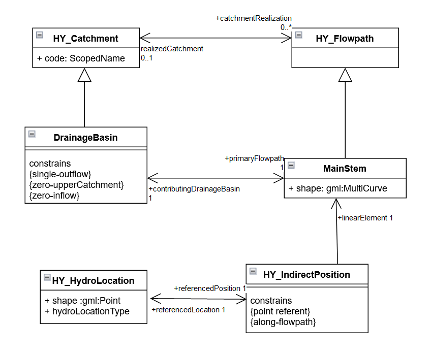
Figure 3: Unified Markup Language model of Mainstems and Drainage Basins classes and related HY_Features classes that play an important role in hydrologic data indexing and integration.
National Hydrologic Geospatial Fabric Reference and Derived Hydrofabrics
Many hydrologic models require either a uniform discretization of the landscape or a set of catchments that are delineated according to a set of outlet locations (often times referred to as pour points). Some models, such as the current National Water Model , use catchments to connect a continuous representation of local catchment processes to a regional network of water bodies that routes water and tracks on-network storage. In all cases, as shown in Figure 4, it is valuable to recognize a set of important hydrologic locations at which a given model application must either take input (like from a stream gage) or provide output (like at an important piece of infrastructure). Given this, identifiers from a reference hydrofabric that link to other data sources must be present in a specific model application hydrofabric. This process, implemented in the NHGF Derived Hydrofabrics (lower tiers of Figure 5) requires careful engineering of data processing workflows aiming to preserve the hydrologic character or meaning of the reference hydrofabric features while creating a set of modeling units that are suited to a given application.
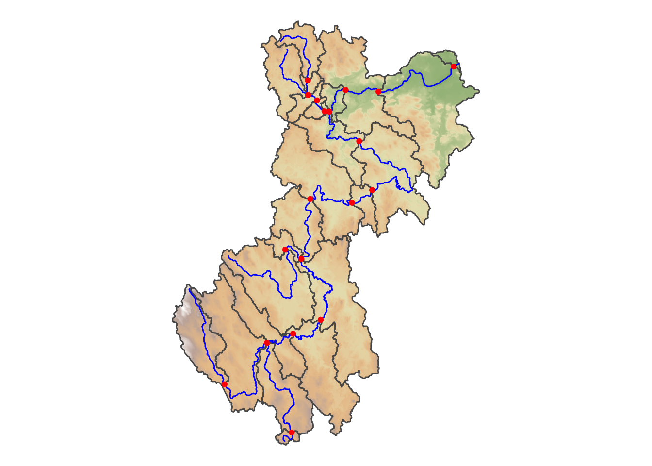
Figure 4: Hydrologic models often recognize important points that form the inlets and outlets of catchment modeling units. Within catchments, hydrologic process can be represented using any modeling method and a hydrofabric network and points of interest encompass and connect local processes to regional flow networks.
The National Hydrologic Geospatial Fabric Reference and Derived Hydrofabrics data release is (as of December 2022) provisional and subject to revision and being made available publicly to provide collaborators and early adopters access to best available open science progress.
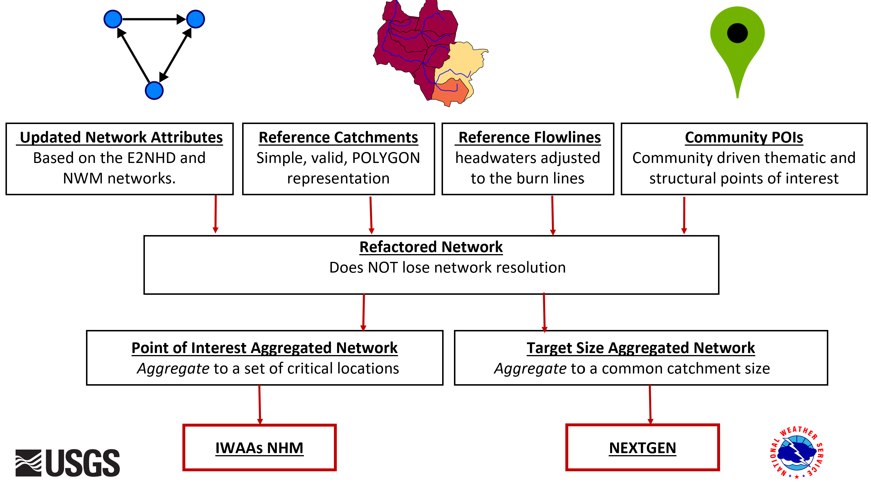
Figure 5: A reference hydrofabric is composed of network connectivity, catchment divides, flowlines, and points of interest. The reference components can be processed into model-specific hydrofabrics in a two-step process.
The data release includes four parts:
- Reference Hydrofabric: Shown in the top tier of Figure 5. Includes identifiers for mainstems and hydrographic features with a carefully constructed set of topological, physical, and geometric feature attributes. Carefully prepared geospatial representations of flowlines, catchments, and points of interest are included as well.
- Refactored Hydrofabric: A processed version of the reference hydrofabric where very small (less than about 500m flowline length) catchments have been consolidated into larger ones and very large catchments (greater than about 2km flowline length) are split apart to limit size or to better represent important network outlets. When refactoring, network density is preserved and all hydrologic locations from the reference hydrofabric are preserved.
- Target Size Hydrofabric: A version of the refactored hydrofabric that has been aggregated to achieve a specific target size of resulting catchment with prescribed upper and lower size limits. Important hydrologic locations from the refactored hydrofabric can be preserved (e.g. gage locations) but most catchment outlets are implied by the need to achieve a specified target catchment size.
- “Point of Interest” hydrologic location Aggregated Hydrofabric: A version of the refactored hydrofabric that has been aggregated as much as possible while maintaining a connected network for a provided set of on-network hydrologic locations. Some catchments can be very large where few points of interest are needed and other catchments may be very small where points of interest are close together.
The data production workflow for these datasets results in model-specific hydrofabrics to serve the needs of a daily time step hydrologic model being constructed for the U.S. Geological Survey National Integrated Water Availability Assessment and National Water Census and a hourly time step hydrologic model to serve the needs of the National Weather Service Next Generation Water Modeling Framework and lead to the implementation of the National Water Model. For more information or to get involved, reach out to Dave Blodgett dblodgett@usgs.gov and check the NHGF Reference and Derived Hydrofabrics for updates in the coming months.
Categories:
Related Posts
The Network Linked Data Index (NLDI) Geoprocessing with OGC API Processes
April 12, 2022
The Network Linked Data Index (NLDI) is a search engine that indexes data to the flowpaths and/or catchments of a river network and provides discovery services based on position in that network. Like a search engine, it can cache and index new data. It also offers some convenient data services like basin boundaries and accumulated catchment characteristics.
The Network Linked Data Index and geoconnex.us
May 14, 2021
The Network Linked Data Index (NLDI) is a search engine that uses the river network as it’s index. Like a search engine, it can cache and index new data. Beyond indexing and data discovery, it also offers some convenient data services like basin boundaries and accumulated catchment characteristics.
The Hydro Network-Linked Data Index
November 2, 2020
Introduction
updated 11-2-2020 after updates described here .
updated 9-20-2024 when the NLDI moved from labs.waterdata.usgs.gov to api.water.usgs.gov/nldi/
The Hydro Network-Linked Data Index (NLDI) is a system that can index data to NHDPlus V2 catchments and offers a search service to discover indexed information. Data linked to the NLDI includes active NWIS stream gages , water quality portal sites , and outlets of HUC12 watersheds . The NLDI is a core product of the Internet of Water and is being developed as an open source project. .
Network Linked Data Index (NLDI) Update and Client Applications
September 30, 2020
In August 2020, the Hydro Network Linked Data Index (NLDI) was updated with new functionality and some changes to the existing Web Application Programming Interface (API). This post summarizes these changes and demonstrates Python and R clients available to work with the functionality.