
New Feature - WDFN Home
New landing page to discover data available on Water Data for the Nation
We are excited to announce a new home page for Water Data for the Nation at waterdata.usgs.gov . The WDFN Home page will serve as a landing page and central hub for the WDFN ecosystem. This home page replaces our legacy home page and helps to drive users to common features of interest. Each tile card helps to direct users to data offerings within waterdata.usgs.gov. All previously offered data are still navigable through this new homepage; however, our most popular and highly requested features are now available on WDFN Home.
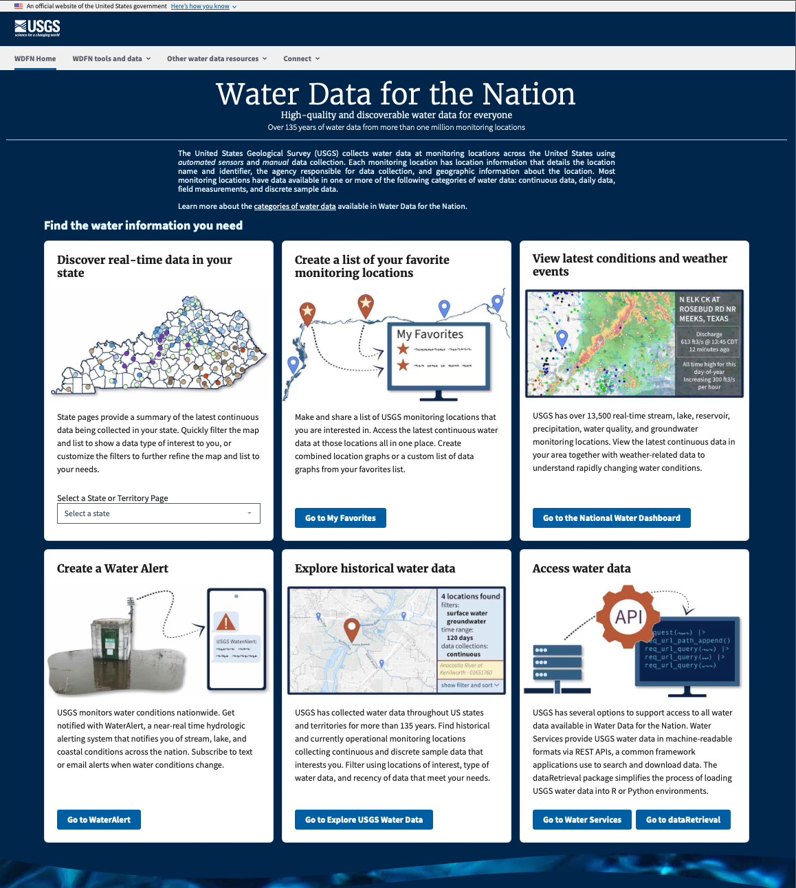
Screenshot of WDFN Home showing tiles that link out to different data offerings
Key Features
Submenus have been updated throughout the WDFN ecosystem for easy navigation to WDFN Home from all pages in WDFN. In addition, tiles are available on the WDFN Home page to point users to popular features.
Each tile represents a different way to explore data on WDFN, highlighting different pages that help users discover data in areas of interest. Tiles currently point to the following features:
- Discover real-time data in your state: see current water conditions from all monitoring locations in a state that collect continuous data. Learn more about the state page.
- Create a list of your favorite monitoring locations: create a custom list of USGS monitoring locations that can be referenced to access the latest continuous water data for several locations at once. Learn more about how My Favorites works.
- View latest conditions and weather events: the National Water Dashboard helps users view the latest continuous data together with weather-related data.
- Create a Water Alert: Subscribe to text or email alerts on water conditions. Learn more about how Water Alert works.
- Explore historical water data: Find all monitoring locations that have collected continuous and discrete sample data by filtering locations on a map, letting users select specific data types and areas of interest. Learn more about how to explore historical water data.
- Access water data programmatically: Access machine-readable formats of water data via APIs.
What’s next?
We will be evaluating feedback on the new page as it comes in from our users to find out how the page is working. Our team uses user-centered design processes to determine what to prioritize next. Let us know how the page is working for you by emailing wdfn@usgs.gov .
Categories:
Related Posts
Metadata in Water Data for the Nation
December 29, 2025
Introduction
Metadata are crucial to interpreting and understanding USGS water data. Metadata are data that provides information about other data. They provide important context to the water data you are viewing on WDFN pages or downloading from USGS Water Data APIs . USGS water data metadata includes codes and abbreviations, such as parameter codes, method codes, and observed properties.
Centralized Water Data in WDFN
December 23, 2025
Introduction
There have been a lot of changes to how you access USGS water data as we work to modernize data delivery in Water Data for the Nation (WDFN) and decommission NWISWeb. WDFN is no longer organizing data based on discipline specific landing pages (e.g., surface water, groundwater, water quality, and water use). WDFN also no longer provides a dedicated page displaying the data inventory or “summary of all available data” for each monitoring location as these features have been consolidated into modernized webpages. These changes will simplify our data delivery and enable all data collection categories to be found from the same pages and tools. This post will orient you to where to find the water data you need.
Daily data in Water Data for the Nation
November 21, 2025
There have been a lot of changes to how you access USGS water data as we work to modernize data delivery in WDFN and decommission NWISWeb. As we centralize and re-organize data delivery in WDFN, we have recently set out to describe different types of water data according to data collection categories . We started with re-organizing and expanding the data collection categories that are delivered on the Monitoring Location Page and are now working to deliver additional data collection categories on other WDFN pages as well. This blog is part of a series to help orient you to where you can find different types of data in WDFN pages and services. In this post, we want to focus on how you can access daily data in WDFN.
NWISWeb Decommission Campaign 2
November 21, 2025
Public USGS Webinar: Water Data for the Nation – New Features and NWISWeb Decommissioning
In this webinar, we highlight important changes in how we deliver water data. These changes are part of a long-term effort to modernize our Water Data for the Nation (WDFN) systems, improve performance, and better serve both internal and public users.
Decommissioning Legacy gwlevels and SensorThings APIs – Fall 2025
September 23, 2025
Background
For over 15 years, the USGS has provided machine-readable and automated access to water data via the WaterServices family of application programming interfaces (APIs), which are hosted at https://waterservices.usgs.gov/ . These APIs underpin all other USGS web delivery products – including products such as the National Water Dashboard and Water Data for the Nation (WDFN) – and have been incredibly effective at delivering water data to the public. Between October 2024 and March 2025 alone, these legacy APIs have handled more than 1.6 billion requests from almost 3.5 million distinct IP addresses.