
Next Generation Monitoring Location Pages Update
Our Next Generation Monitoring Location Pages continue to receive updates based on our priorities and your feedback. Legacy real-time pages will redirect to NextGen pages in September 2022 and legacy pages will be decommissioned in July 2023.
Last updated August 12th, 2022
On April 11th, we hosted a public webinar during which we updated our stakeholders on the progress of replacing Legacy real-time pages with Next Generation Monitoring Location Pages.
We anticipate to begin redirecting Legacy pages to NextGen pages in September 2022. This means when you click a bookmark for a Legacy page, your web browser will automatically redirect you to the NextGen page, but you’ll still be able to access the Legacy page if you click on the link at the top of NextGen pages.
Notice the Legacy real-time page link at the top of a Next Generation Monitoring Location Page.
After addressing many highly-requested features, we anticipate decommissioning the NWISWeb Legacy current-conditions real-time pages in July 2023.
Recently released features
✔ Add scale to map (complete!)
✔ Provide option to download data near data tables (complete!)
✔ data sortable by time
✔ Make Facebook shares more compelling with images
✔ Daily statistics for the latest day
✔ Multi-parameter feature (2 parameters on the same graph)
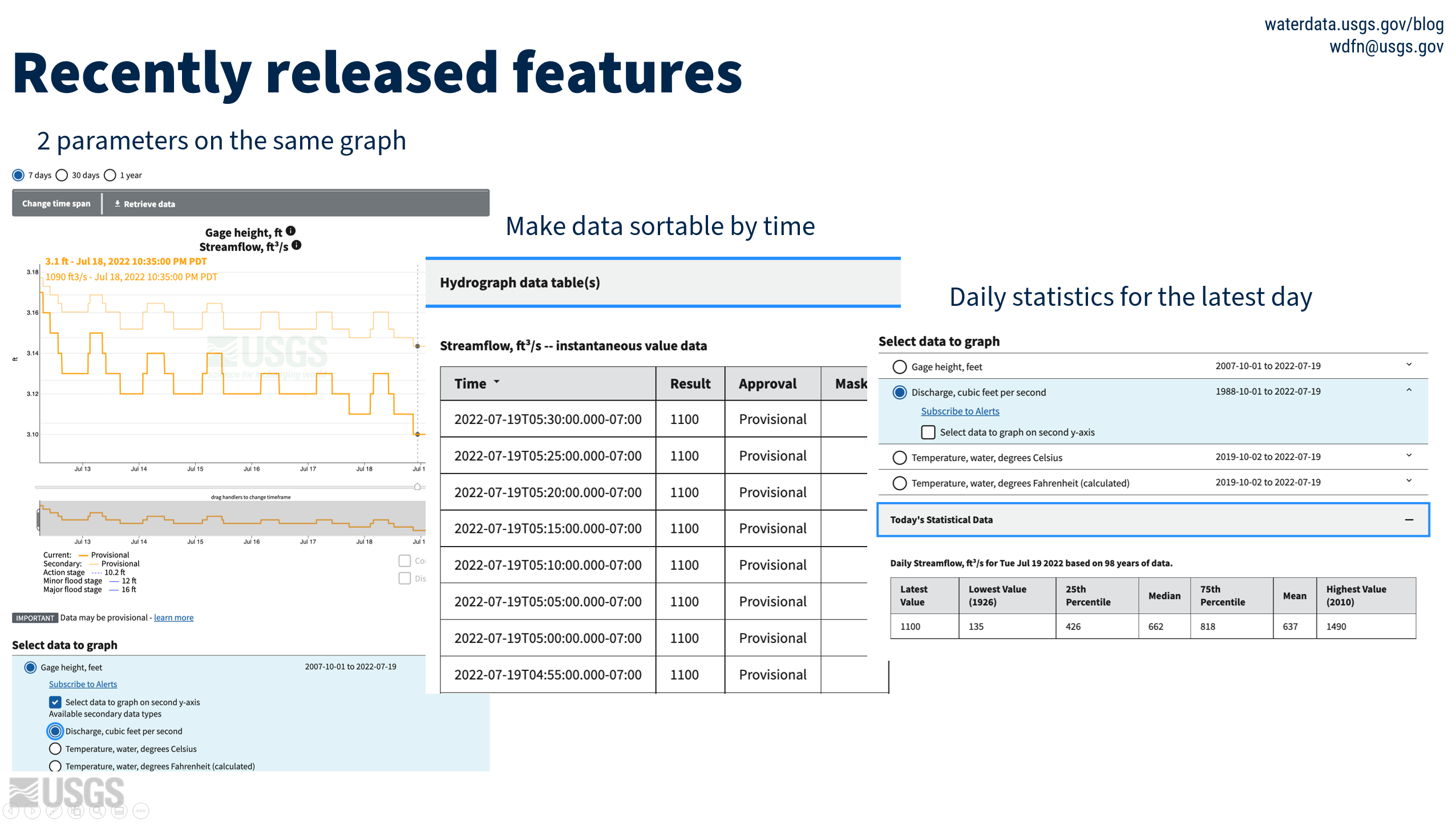
Here are a few examples of recently released features. Having 2 parameters on the hydrograph was a highly requested feature which now gives users the option to compare data. We made the data table sortable, giving the users a choice to see their data in a specific order. Finally, we added the daily stats table to the monitoring location pages.
Only remaining feature we need to add before the redirect in September 2022
- New zoom options to improve interactivity with graph and axis
Some features we anticipate addressing before Legacy decommission in July 2023
- Better download capability
- Possible expansion of WSC-specified text fields like manuscript, location-level revisions (interaction with SIMS)
- Make wind direction parameter a set of discrete measurements (not continuous line)
- Features to better show water quality samples: Showing some field visit data with continuous water quality measurements; Having a summary of available water quality data
A few features we know are essential
- Cooperator access – there is an access level for cooperators for semi-public data
- Discrete data, field visits, and stats access - we’ve heard this is important for our advanced users
- Multi-station data access - we plan to conduct a discovery with our users to determine how to best offer this highly requested feature
Get involved! Have your voice heard
Want to test the multi-station feature in beta? Email us: wdfn_usabilitytesting@usgs.gov with the subject: Multi-Station Feature.
Have more questions about the modernization of Monitoring Location Pages?
Check out this older blog post of ours for more context, but please always refer to the most recent communications for the most accurate product timeline.
Related Posts
Redirecting the Next Generation Monitoring Location Pages
October 14, 2022
During the week of October 17th, many links to legacy real-time pages will be redirected to the Next Generation monitoring location pages. This means that bookmarked links to the legacy real-time pages will be redirected automatically to the NextGen monitoring location pages.
New Feature - SensorThings API
August 3, 2023
SensorThings coming soon to WDFN. Use the SensorThings API to access national-scale data for quicker application development and the ability to map those results. This API provides users with a flexible way to interconnect data, devices, and application over the Web.
Data Graphs in Water Data for the Nation
June 22, 2023
We have been hard at work designing how to view our water data on graphs in Water Data for the Nation (WDFN). Right now, the primary option is monitoring location pages which have a graph that can look at data over the entire period of record, but this year we’re introducing two additional options to view graphed data!
New Feature - All Graphs
June 6, 2023
We are excited to announce that a new feature is now available to Monitoring Location Pages as part of our modernization efforts. The All Graphs page will show a series of individual graphs of all current sensor data collected at a single location.
New Feature - Explore USGS Water Data
June 6, 2023
Locating and filtering data by specific parameters is coming soon! Explore USGS Water Data provides users with a dynamic tool to customize and throttle targeted information to meet the needs of users.