


NWISWeb Decommission Campaign 3
Details of NWISWeb Decommission Campaign 3 from November 2026 to February 2027
What's on this page
Public USGS Webinar: NWISWeb Decommissioning Campaign 3
NWISWeb launched real-time data pages in 1995 and has hosted more than 7 million annual unique visitors, billions of successful page requests, and terabytes of data delivered. After several years of modernization, we are beginning the final decommissioning or turning off of legacy NWISWeb webpages. This means that pages that you may have relied on for years are going away.
This webinar will share information on NWISWeb Decommission Campaign 3, which will retire all remaining NWISWeb pages and WaterServices. Campaign 3 is expected to be ongoing from November 2026 through February 2027.
Join the External Webinar on October 1, 2026 at 1pm Central using this link.
This blog will share information on NWISWeb Decommission Campaign 3, which will retire all remaining NWISWeb pages and WaterServices. Campaign 3 is expected to be ongoing from November 2026 through February 2027 and is the last of three campaigns to decommission legacy NWISWeb pages currently hosted at https://waterdata.usgs.gov.
All remaining NWISWeb pages will be decommissioned this fall and winter, including:
- /uv
- /peaks
- /ratings and /get_ratings
- /revisions
- NWISMapper (maps.waterdata.usgs.gov/)
- All WaterServices URLs at waterservices.usgs.gov/
Legacy NWISWeb Decommissions
A couple of key notes about this campaign:
- This is the final decommission of NWISWeb. After February 2027, there will be no longer be any access to legacy NWISWeb pages.
- WaterServices APIs will be intentionally throttled and undergo several planned outages before their final decommissioning. More about the planned decommission will be available soon on another blog post.
Table 1: Legacy NWISWeb Campaign 3 Decommission Scope
| Legacy NWISWeb Category | Legacy Page Examples This page and sub-pages retired as part of Campaign 3 | WDFN Page Traffic redirected to this modernized next generation page |
|---|---|---|
| Current and historical observations (/uv) | waterdata.usgs.gov/nwis/uv/?search_site_no=01436000&legacy=1 |
|
| Peak streamflow (/peaks) | nwis.waterdata.usgs.gov/usa/nwis/peak/?site_no=01018500 |
|
| Rating curves (/ratings and /get_ratings) | waterdata.usgs.gov/nwisweb/data/ratings/exsa/USGS.05423500.exsa.rdb |
|
| Revisions (/revision) | waterdata.usgs.gov/nwis/revision/?site_no=01018500 |
|
| NWISMapper | apps.usgs.gov/nwismapper/ |
|
| WaterServices | waterservices.usgs.gov/ |
|
URL Cleanup
The full listing of URL cleanup categories included in Campaign 3 are in the following table. A couple of key notes about this campaign:
- A best practice in web design is to retire redirects after a year. There are a variety of benefits including keeping the search engines up-to-date on the best pages for which to send traffic. Campaign 2 introduced redirects a year ago, so in Campaign 3 the team will do the final cleanup where the page no longer exists and there is no longer a redirect. If any bookmarks or external links have not been updated, users will receive 404: Page not Found errors for these pages. Reach out to wdfn@usgs.gov if you need support finding the new link.
Table 2: Campaign 3 URL Cleanup Scope
| Legacy URL Category | Legacy URL Examples |
|---|---|
| Annual Statistics (/annual) redirects | waterdata.usgs.gov/nwis/annual/?search_site_no=01436000 |
| Monthly statistics (/monthly) redirects | waterdata.usgs.gov/nwis/monthly/?search_site_no=01436000 |
| Daily statistics (/dvstat) redirects | nwis.waterdata.usgs.gov/nwis/dv?referred_module=sw&site_no=12392500 |
| Groundwater Summary (/nwis/gw) redirects | nwis.waterdata.usgs.gov/nwis/gw |
| Groundwater Levels (/gwlevels) redirects | nwis.waterdata.usgs.gov/nwis/gwlevels?search_site_no=390925111455301 |
| USGS Water Data for the Nation Help (help.waterdata.usgs.gov) redirects | help.waterdata.usgs.gov |
| Inventory (/inventory) redirects | waterdata.usgs.gov/nwis/inventory?site_no=08390500&agency_cd=USGS |
| Measurements (/measurements) redirects | waterdata.usgs.gov/nwis/measurements?state_cd=ak |
| NWIS Home (/nwis) redirects | waterdata.usgs.gov/nwis and waterdata.usgs.gov/ca/nwis |
| Real-Time Current Conditions Map (/rt) redirects | nwis.waterdata.usgs.gov/nwis/rt and nwis.waterdata.usgs.gov/mo/nwis/rt |
| Site Information Summary (/nwis/si) redirects | nwis.waterdata.usgs.gov/nwis/si |
| Surface Water Summary (/nwis/sw) redirects | nwis.waterdata.usgs.gov/nwis/sw |
| Water Quality Summary (/nwis/qw) redirects | nwis.waterdata.usgs.gov/nwis/qw |
| Water Year Summary (/wys_rpt) redirects | waterdata.usgs.gov/nwis/wys_rpt/ |
Special Use Cases
We know that the redirects will not handle all uses of the legacy pages. This section covers known special use cases of decommissioned pages that may want to explore other options in WDFN. Each section discusses the capability of legacy and what options are available that were not automatically handled by the redirect. This guide will be updated as questions come in through user support to help guide users working through common issues.
Use Case: Display a series of graphs
Applies to: Current and Historical Conditions (/uv)
Current and Historical Conditions (/uv) can be configured to show a page with a series of graphs with selected data. The data shown could be for one or more locations at a time. Many users have bookmarked pages with this configuration that cannot be redirected correctly.
For a single location, you can see a similar view containing a series of graphs with continuous data on MLP: All Graphs. You can reach this page from the “View related graphs” button on MLP, selecting the All Continuous data graphs link, or my adding “/all-graphs” after the monitoring location ID in the URL, such as https://waterdata.usgs.gov/monitoring-location/USGS-03341500/all-graphs.
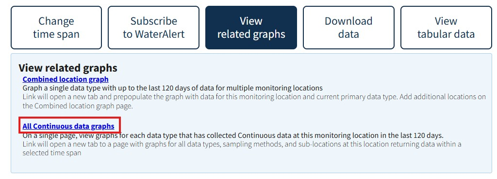
Click All Continuous data graphs within the View related graphs button to see a series of graphs for all continuous data types, similar to the familiar view on the legacy NWISWeb /uv pages.
To view these graphs for multiple locations, similar capability has been included in My Favorites for graphs showing the latest conditions. Learn more about the My Favorites page to see if it works for you. To recreate your legacy NWISWeb view of a series of graphs from multiple locations, use the following steps:
- Open an unconfigured My Favorites page. Keep your legacy NWISWeb URL nearby for reference.
- Add locations in the “Add/remove locations” button.
- You may have a list already available in your legacy URL. Locations are 8 to 15 digit numbers and can be found in the legacy NWISweb URL after “site_no” or “multiple_site_no” generally. Pressing the “update locations” button updates the page with the names of those locations and the data available.
- Want to add locations to your My Favorites list? Use the map on National Water Dashboard or on a State Page, for example Arizona water conditions to find locations collecting continuous data and copy the location ID over to the My Favorites list.
- To see all the graphs of continuous data from the locations in your favorites list, start by selecting the “Graph favorites” button. In this case, we want to select the second option “Show selected locations and data types as graphs on a single page”. Follow the instructions to select the data you want graphed
- Select the continuous data types you are interested in viewing (select the “All” button to save yourself some clicks). Any data you do not select will not be shown on the graph view, so think about which are useful to see plotted!
- Scroll down to find the links for Grouped by location and Grouped by data type, which bring you to a page that should feel familiar to you, with a series of graphs of continuous data for the locations you selected. Remember to bookmark this new page!
Capability: Using filters to make a list of sites
Applies to: Current and Historical Conditions (/uv)
Within the pages being decommissioned, there are several instances of NWISWeb pages where users can utilize filters to sort through monitoring locations. When these filters are used, the most commonly selected output is a list of sites that match the filters.
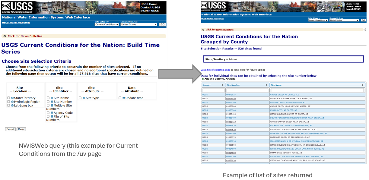
Example of NWISWeb Query page leading to a list of sites.
On WDFN, either a map-based or web service option can be used to filter locations and build a site list.
If you are looking to find locations, try out Explore USGS Water Data which uses a combination of location and data filters to help users find locations that collect data of interest. Explore USGS Water Data can be used to find locations that collect any category of USGS water data, including continuous (sensor), daily, field measurements, and discrete sample data. You could also try your State Page, for example Arizona water conditions, where you can customize filters for the continuous data types and time period you’re interested in, then group the list of monitoring locations in the state according to county, HUC-06, or HUC-08. You can access a comma-separated list of your filtered locations in the “Get more information” action button or directly update your My Favorites list.
Alternatively, it may be easiest to pull the data using the services:
- Use the Download data form to download from any of the Water Data APIs in your browser window.
- Browse the Water Data APIsfor the full catalog of data services, including continuous data, field measurements, groundwater, water quality, and others.
- Find parameter codes and other reference lists in the metadata services
- Return data for multiple sites in a single request by creating a complex query.
- Import USGS data directly into GIS easily using this QGIS example
- If you are working in R or Python, use the dataRetrieval package to access USGS and EPA hydrology and water quality data
What should users do as we decommission?
- Attend the webinar on Campaign 3. An invitation will be coming soon to join our Teams Live Event to learn about the NWISWeb decommission and will be linked here when available.
- Missed the webinar? The recording will be posted shortly afterwards and linked here. Reach out with follow-up questions to wdfn@usgs.gov.
- Identify the legacy NWISWeb pages you rely on and move your bookmarks early. If you use a bookmark to a decommissioned page, consider taking the following steps:
- Explore the new page! Many of our new pages can be configured to your liking and the default state may not be the best match for what you want to see when the page loads. Press buttons and change your views of the data until you find the one that works best for you. If this page doesn’t seem like it fits what you were doing before, review the Special Use Cases section of this blog to see if we have any advice. Reach out to wdfn@usgs.gov with questions, we are here to help.
- Reset your bookmark. Once you have the page configured as you like or have found a better page to use, make sure to reset your bookmarks. The redirects will be up for 1 year but after that you will lose direct access with your current bookmark.
- Migrate applications and programs to use the modernized Water Data APIs. Consult the migration guide for help in updating data pulls, and reach out to wdfn@usgs.gov with any questions.
Categories:
Related Posts
NWISWeb Decommission Campaign 2
November 21, 2025
Public USGS Webinar: NWISWeb Decommissioning Campaign 3
NWISWeb launched real-time data pages in 1995 and has hosted more than 7 million annual unique visitors, billions of successful page requests, and terabytes of data delivered. After several years of modernization, we are beginning the final decommissioning or turning off of legacy NWISWeb webpages. This means that pages that you may have relied on for years are going away.
This webinar will share information on NWISWeb Decommission Campaign 3, which will retire all remaining NWISWeb pages and WaterServices. Campaign 3 is expected to be ongoing from November 2026 through February 2027.NWISWeb Decommission Campaign 1
December 6, 2024
Public USGS Webinar: NWISWeb Decommissioning Campaign 3
NWISWeb launched real-time data pages in 1995 and has hosted more than 7 million annual unique visitors, billions of successful page requests, and terabytes of data delivered. After several years of modernization, we are beginning the final decommissioning or turning off of legacy NWISWeb webpages. This means that pages that you may have relied on for years are going away.
This webinar will share information on NWISWeb Decommission Campaign 3, which will retire all remaining NWISWeb pages and WaterServices. Campaign 3 is expected to be ongoing from November 2026 through February 2027.NWISWeb Decommission Campaign Summary
December 6, 2024
Public USGS Webinar: NWISWeb Decommissioning Campaign 3
NWISWeb launched real-time data pages in 1995 and has hosted more than 7 million annual unique visitors, billions of successful page requests, and terabytes of data delivered. After several years of modernization, we are beginning the final decommissioning or turning off of legacy NWISWeb webpages. This means that pages that you may have relied on for years are going away.
This webinar will share information on NWISWeb Decommission Campaign 3, which will retire all remaining NWISWeb pages and WaterServices. Campaign 3 is expected to be ongoing from November 2026 through February 2027.Centralized Water Data in WDFN
December 23, 2025
Introduction
There have been a lot of changes to how you access USGS water data as we work to modernize data delivery in Water Data for the Nation (WDFN) and decommission NWISWeb. WDFN is no longer organizing data based on discipline specific landing pages (e.g., surface water, groundwater, water quality, and water use). WDFN also no longer provides a dedicated page displaying the data inventory or “summary of all available data” for each monitoring location as these features have been consolidated into modernized webpages. These changes will simplify our data delivery and enable all data collection categories to be found from the same pages and tools. This post will orient you to where to find the water data you need.
Decommissioning Legacy gwlevels and SensorThings APIs – Fall 2025
September 23, 2025
Background
For over 15 years, the USGS has provided machine-readable and automated access to water data via the WaterServices family of application programming interfaces (APIs), which are hosted at https://waterservices.usgs.gov/. These APIs underpin all other USGS web delivery products – including products such as the National Water Dashboard and Water Data for the Nation (WDFN) – and have been incredibly effective at delivering water data to the public. Between October 2024 and March 2025 alone, these legacy APIs have handled more than 1.6 billion requests from almost 3.5 million distinct IP addresses.