
Next Generation Monitoring Location Pages Go Live Soon!
NWISWeb is our legacy water data delivery system. Over the next few years, Water Data for the Nation (WDFN) will slowly replace NWISWeb. We're modernizing one room at a time, and we've started with the legacy real-time current conditions pages, now known as Next Generation Monitoring Location Pages.
Last updated October 21, 2021
To learn more about these changes, watch the recording of our October 2021 public webinar.
What are Monitoring Location Pages?
Monitoring location pages are web pages that the USGS Water Mission Area offers to display important water data like discharge (also referred to as streamflow), gage height, precipitation, water-levels, temperature, etc. Thousands of people use USGS water data each month to make decisions ranging from recreation to emergency management.
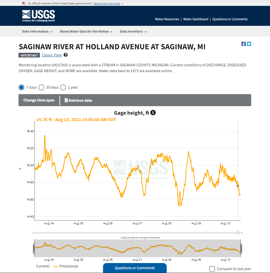
A Next Generation Monitoring Location Page for ‘04157005, which is associated with a STREAM in SAGINAW COUNTY, MICHIGAN’.
Why Are We Changing Them?
The original, legacy current-conditions real-time pages have largely looked the same since their inception in 1995. We are confident they were one of the first displays of real-time water data anywhere in the world at a time when the web was only 5 years old and rarely displayed “live” content of any kind. Wow!
The technology used to produce the original pages, what we call legacy pages, is now outdated, and prevents crucial updates from being made. But we need to meet accessibility standards, stay modern, and increase user satisfaction, so we have created new, Next Generation monitoring location pages. We give thanks to the decades of skilled software-programming work put into the legacy pages and we recognize how much they have provided to the public. We are thrilled to modernize our water data delivery as we “go live” with the NextGen pages.

Here’s an example of a legacy page, showing ‘monitoring location 01584050 LONG GREEN CREEK AT GLEN ARM, MD’.
What Does “Live” Mean?
Pages will continue to improve over time. It’s like we’re remodeling our house while we’re still living in it. We started with our most prominent and visible room—the one that receives over 90 percent of our visitors! But in the coming years we’ll be remodeling other rooms, too. And we’ll do all this while still living in the house, so we will be making our plans carefully, to avoid unnecessary dust and loud disruptions.
NextGen pages have been online and accessible for approximately two years, in what we have called the beta stage of our agile development process. Beta means the pages are accessible to the public and available for user testing. During beta, we have made many changes. Very soon, pages will no longer be in the beta stage. They will be fully operational - live! This doesn’t mean the pages are set in stone though. We will keep updating the pages. Check back soon for a road map of our progress.
Learn more about how we work and use the agile development process to display high-quality water information. Discover how we’ve improved the pages so far. The software that generates the Water Data for the Nation web pages is available for viewing in our public USGS Git repository. You are welcome to inspect the programming, review code changelogs, or even clone your own copy of the software for your own software endeavors. We hope you will find our modern website software possesses loosely coupling, service orientation, and other qualities that make it amenable to be adapted to other purposes by any interested person or group.

The Agile Development Process as the WDFN team uses it.
When will “Live” happen?
Now, late 2021
Right now NextGen pages are ready for wide-spread use. Soon they will no longer have the beta tag that they have now.
March, 2022
Your web browser bookmarks for the legacy pages will redirect you to NextGen pages. If there are features you need that are exclusive to legacy pages, we’re here to reassure you that you will still be able to access legacy pages until January 2023. You’ll be able to easily access legacy pages with the click of one link which will be at the top of NextGen pages.
January, 2023
Legacy real-time data pages will be fully decommissioned and no longer available to access.
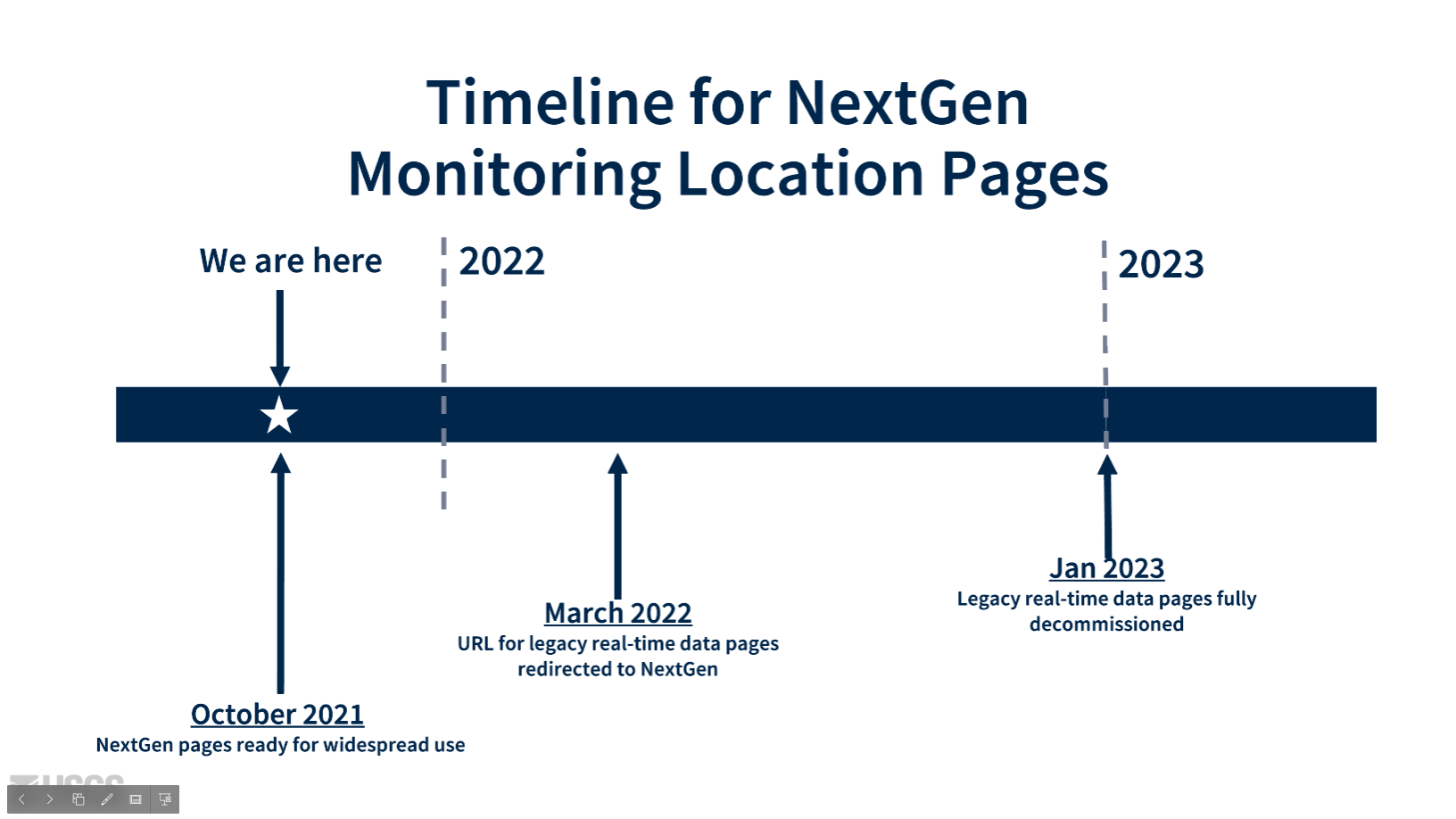
The timeline of changes for Next Generation monitoring location pages.
How Are NextGen Pages Different from Legacy Pages?
These NextGen pages have new features, offering more than just a 1:1 replacement of legacy pages.

A side by side comparison of the next generation monitoring location page versus the legacy real time page for monitoring location 04157005, which is associated with a STREAM in SAGINAW COUNTY, MICHIGAN.
5 Key Differences
Data-first: Hydrograph at top, except for key alerts
Interactive: Featuring a clickable, zoomable hydrograph with the ability to compare prior data
Compact & Mobile-First: More things on one page – monitoring location metadata, water-data inventory, groundwater data, interactive map, etc, all summarized on one page
Geo-located: Featuring a map with flowlines, shaded watershed area, and nearby monitoring locations
Affiliated networks: A monitoring location belong to larger groupings of monitoring locations, and these pages let you explore those groupings to see the bigger picture of water resources
Check out our other resources
Webinar
We hosted a public webinar in October 2021. Did you miss the webinar? Watch the recording on the USGS website or on the USGS YouTube channel.
Social Media
Follow us on Twitter (@USGS_Water) and Instagram (@USGS_Streamgages)!
How-To Video
In this short video, discover how you can easily use these Next Generation monitoring location pages. We’ll walk you through common functions and page uses. Watch the video in English, on our website. Watch the video in English, on YouTube.
Introduction to Water Data for the Nation Video
We recorded this short video just for you. Tune in for more information on our water data delivery. This video includes a brief history of our legacy system, an introduction to the NextGen pages, and the timeline of these changes. All videos have closed captioning capabilities, and most videos have Spanish captions as well.
Watch the video in English, on our website.
Watch the video in English, on YouTube.
Watch the video with Spanish closed captioning, on our website.
There are other modernizations upcoming for all of NWISWeb, but we will update you when we get closer.
#EnGageWithUSGS! #WeHearYou
Is there something specific you’d like to address that isn’t covered in the resources we have? Do you have a new feature request? Email us: WDFN@usgs.gov.
During this beta phase of the next generation pages, ‘we asked you, the user, how these pages could better serve you’. Pages will continue to be improved iteratively to create discoverable, accessible, and usable Water Data for the Nation, and your feedback is always welcome.
Categories:
Related Posts
Modernizing How You Access Water Data | Webinar on Oct 13 | Recording Available
October 1, 2021
Missed the webinar? Watch the recording The recording of this webinar can be viewed on the USGS website or on the USGS YouTube channel. Let us know your thoughts!
FAQ for Next Generation Monitoring Location Pages
September 24, 2021
Last updated May 3rd, 2022 For ease of use, we recommend you CTRL+F (for Windows) or Command+F (for Mac) to search this page for the section that relates to your question.
How to Use Next Generation Monitoring Location Pages
September 8, 2021
Last updated April 7th, 2022 Welcome to our how-to guide for WDFN's Next Generation Monitoring Location Pages Looking for guidance on how to use the NextGen pages?
The WDFN tech stack
April 14, 2022
The goal of this post is to give a technical reader an idea of what technologies the Water Data for the Nation (WDFN) team uses, because it is both varied and ever changing.
Technology Cluster Hire: Usability Specialist and DevOps Positions
April 11, 2022
USGS Water Mission Area 2022 Cluster Hires (updated 4/19/2022) The U.S. Geological Survey Water Mission Area is hiring multiple Term Information Technology (IT) Specialist positions in Usability Research and Development-Operations (DevOps) for enterprise data delivery systems.