
Release Notes for late February and early March 2020
A summary of new features and tools released in late February and early March, 2020
What have we been up to?
- Added handles to brush on the monitoring location page hydrograph
- State of hydrograph saved for bookmarking/linking
- Display upstream basin from NLDI for each monitoring location
- A number of additional graph server parameters
- New data services for monitoring locations
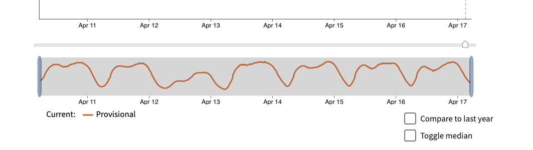
Brush handles added to monitoring location page hydrograph
Based on user feedback, the team upgraded the brush and zoom capability on the hydrograph by adding handles, making it more apparent that the zoom functionality is available and making it easier to use. The handles are also big enough for use on mobile devices.
Screenshot showing handles added to the hydrograph zoom capability.
State of hydrograph saved for bookmarking/linking
WDFN serves a huge range of users. WDFN users are now able to bookmark and share a hydrograph in the way that they requested it. After adjusting a hydrograph with custom date ranges and parameters, a person can copy a link from the address bar, paste it into another browser, and it will populate with a similar set of things. Users can share custom hydrographs generated with specific time-series statistics, parameter codes, dates, and compare settings. For example, a user may be interested in the changes in gage height at the USGS gage Colorado River at Lee’s Ferry, AZ over the course of the November 2012 Glen Canyon Dam High Flow Experimental Release. After choosing a custom time range and the gage height parameter, the URL in the browser can be used to share or return to the same settings.
Use NLDI to display upstream basin from each monitoring location
By utilizing the Hydro Network-Linked Data Index (NLDI), monitoring locations are able to be put in context of a catchment or basin. Each active stream site has an upstream basin in NLDI, as you can see here:
https://labs.waterdata.usgs.gov/api/nldi/linked-data/nwissite/USGS-05429700/basin/
A user who is interested in knowing the upstream basin for a site is can now see it on a monitoring location page map. Showing the upstream basin allows users to better understand if the contributing basin for a monitoring location is large or small, or if downstream locations would be affected by a spill or hazard, among various applications. There are already upstream and downstream NLDI calls in on the monitoring location pages.
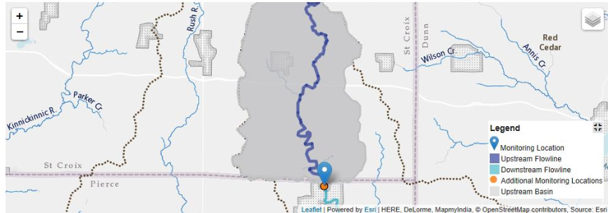
Screenshot of the upstream basin for monitoring location 05370000, Eau Galle River at Spring Valley, WI.
New parameters for the graph-images service
One of the most common requests that we get in feedback is that users want to be able to download an image of the hydrograph. We started on this work with the graph image API, but it only allowed a single parameter, the parameter code.
Now, the image server supports several additional parameters.
Title- allows a title to be placed on the top of the graph describing its location: https://labs.waterdata.usgs.gov/api/graph-images/monitoring-location/09380000/?parameterCode=00060&title=true
Width- allows the width of the image to be varied from 300 to 1200 pixels. This also improves the readability of the graph when the image is small.
Period- previously, the only option for number of days was the most recent 7 days. Now a user can input an arbitrary number of days: https://labs.waterdata.usgs.gov/api/graph-images/monitoring-location/09380000/?parameterCode=00060&title=true&period=p120D
Time ranges- now that users can request a custom time range on the monitoring location page, and they can also request that same time range on the graph server: https://labs.waterdata.usgs.gov/api/graph-images/monitoring-location/09380000/?parameterCode=00060&title=true&startDT=2019-10-01&endDT=2020-01-10
Additional features that we are planning to add to the graph server include
Adding the ability to request a specific time series, like you can with the monitoring location pages
Documenting the API using the OpenAPI standard
Updating the date queries to meet international standards
New features and tools
- We’ve have taken a first step toward completely reconfiguring how we pull data on the backend, as evidenced by showing the new groundwater daily value graph on the development site. This will be pushed to production soon!
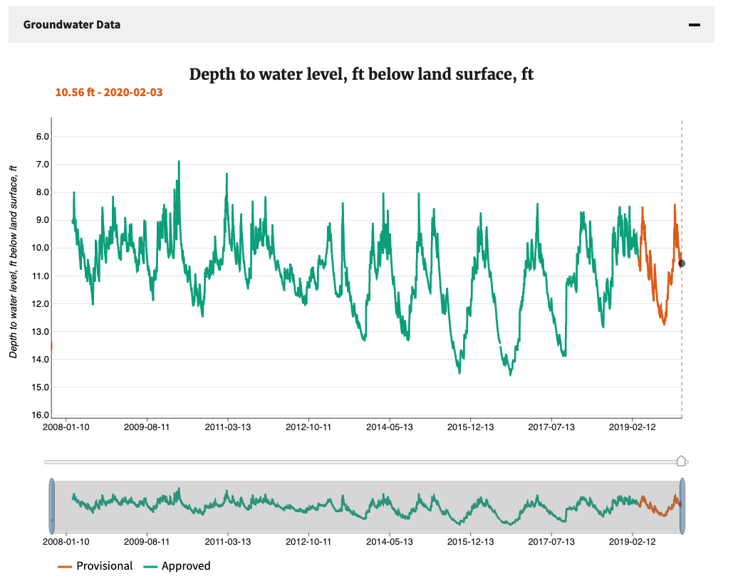
Screenshot of groundwater maximum daily values at CT-D 117 DURHAM, CT. This graph is not yet available on a public site.
- All of the Groundwater Watch networks have been populated in a service, a big step forward on our new networks service: https://labs.waterdata.usgs.gov/api/observations/collections?f=json
What is coming up for next sprint?
waterdata.usgs.gov/networks – page will show a list of all networks with links to specific network pages
Presenting statistical information in a standards-driven format
Allowing networks to be populated by a CSV
Displaying additional network metadata on network pages
Disclaimer
Any use of trade, firm, or product names is for descriptive purposes only and does not imply endorsement by the U.S. Government.
Categories:
Keywords:
Related Posts
Release Notes for July 21st, 2020
July 21, 2020
What have we been up to? Pubs Warehouse moved to the Cloud Behind the scenes work New features and tools Pubs Warehouse on the Cloud The Water Data for the Nation team is the primary development team for another high profile application, the USGS Publications Warehouse.
Release Notes for late March 2020
April 10, 2020
What have we been up to? Image server work Period parameter Axis scaling Networks page New features and tools Image export from monitoring location pages One of the most requested features we receive from users is the ability to export images from the monitoring location pages.
Release Notes for February 28th, 2020
March 2, 2020
The last several months have been exciting. We have been able to complete work related to: Cloud migration of the Water Quality Portal Cloud migration of the Network Linked Data Index (NLDI)
Release Notes for November 13, 2019
November 13, 2019
What have we been up to? This sprint, we have been working on a number of features that are the groundwork for future tools. Most notably, we are developing a working monitoring location services system based on the new Open Geospatial Consortium OGC API-Features standard.
Release Notes for October 16, 2019
October 16, 2019
What have we been up to? This sprint, the team has been working primarily on features that are tied to the cloud version of the USGS Publications Warehouse.