
Release Notes for late March 2020
A summary of new features and tools released in late March, 2020
What have we been up to?
Image server work
Period parameter
Axis scaling
Networks page
New features and tools
Image export from monitoring location pages
One of the most requested features we receive from users is the ability to export images from the monitoring location pages.
The graph image server now is documented using the OpenAPI 3 standard so that downstream developers and others can more easily use this service. The graph image server will allow outside developers to download or embed an image version of the graphs on the new monitoring location pages.
Period of record on monitoring location pages
The monitoring location pages also now display the period of record for instantaneous values for a given parameter, making it easier to request a custom time period:
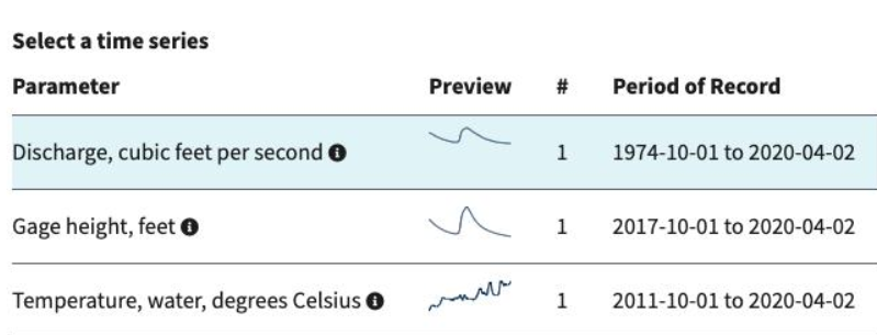
A screenshot showing the available parameters with their periods of record.
Axis scaling
Finally, the axis scaling was made more robust, making it easier for users to see when an event of interest occurred:
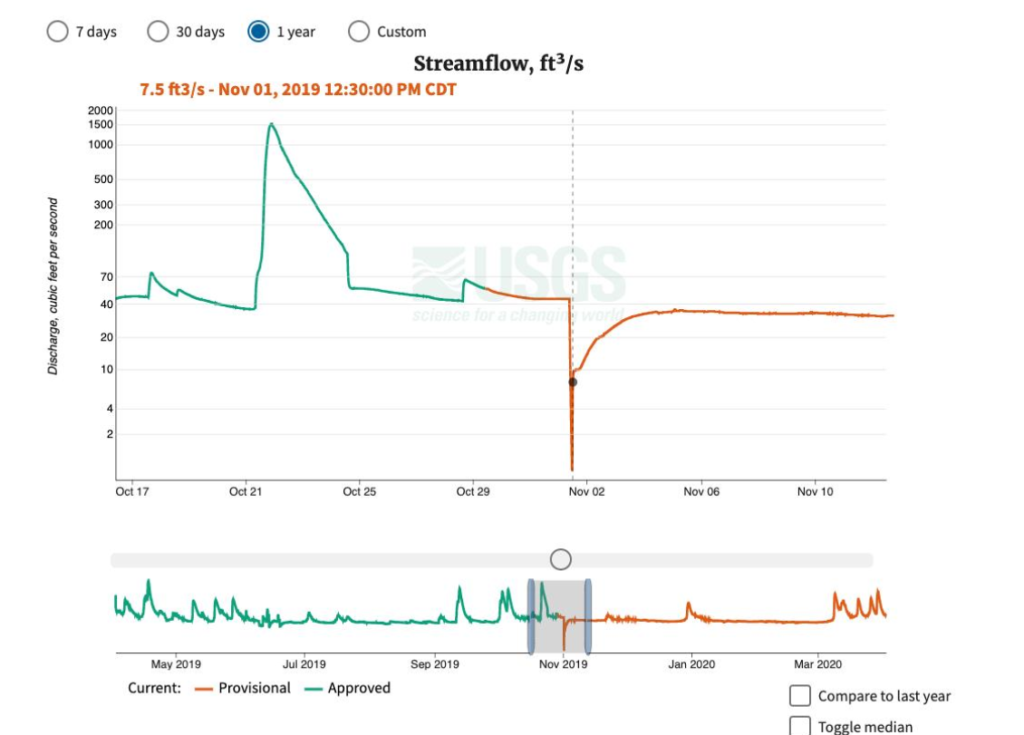
A hydrograph with new, more robust scaling on the y-axis.
Networks Page
The USGS collects monitoring locations into networks, but typically these networks have not been part of our core data delivery on waterdata.usgs.gov. Rather, networks have been presented on ancillary sites, such as Groundwater Watch or sites dedicated to specific networks . Sometimes the networks are curated by scientists, such as the Climate Response Network , while others are based on an algorithm, such as the Below Normal Groundwater Levels Network , and still others are local or regional and based on cooperative agreements or projects, such as the Minnesota Bemidji Toxics Oil Spill Research Site Network . Not surprisingly, the USGS is not the only organization to group geospatial features together, and collections are a core part of the Open Geospatial Consortium’s new standard for presenting the geospatial features, OGC API-Features . OGCAPI-Features is the first of a growing family of new web services standards that is being developed over the next few years. The WDFN team has been building an implementation of OGC API-Features, which you can explore on the OpenAPI 3 based API Documentation . You will also see documenation of a number of different experiments of presenting observation data that are ongoing and we will write about more soon!
All that said, we have harvested a number of the networks from Groundwater Watch to exercise these new services, and you can explore them on a new page dedicated to networks at https://waterdata.usgs.gov/networks/ . From there, you can explore individual networks, such as the Minnesota Prairie Island Indian Community Water-Level Network
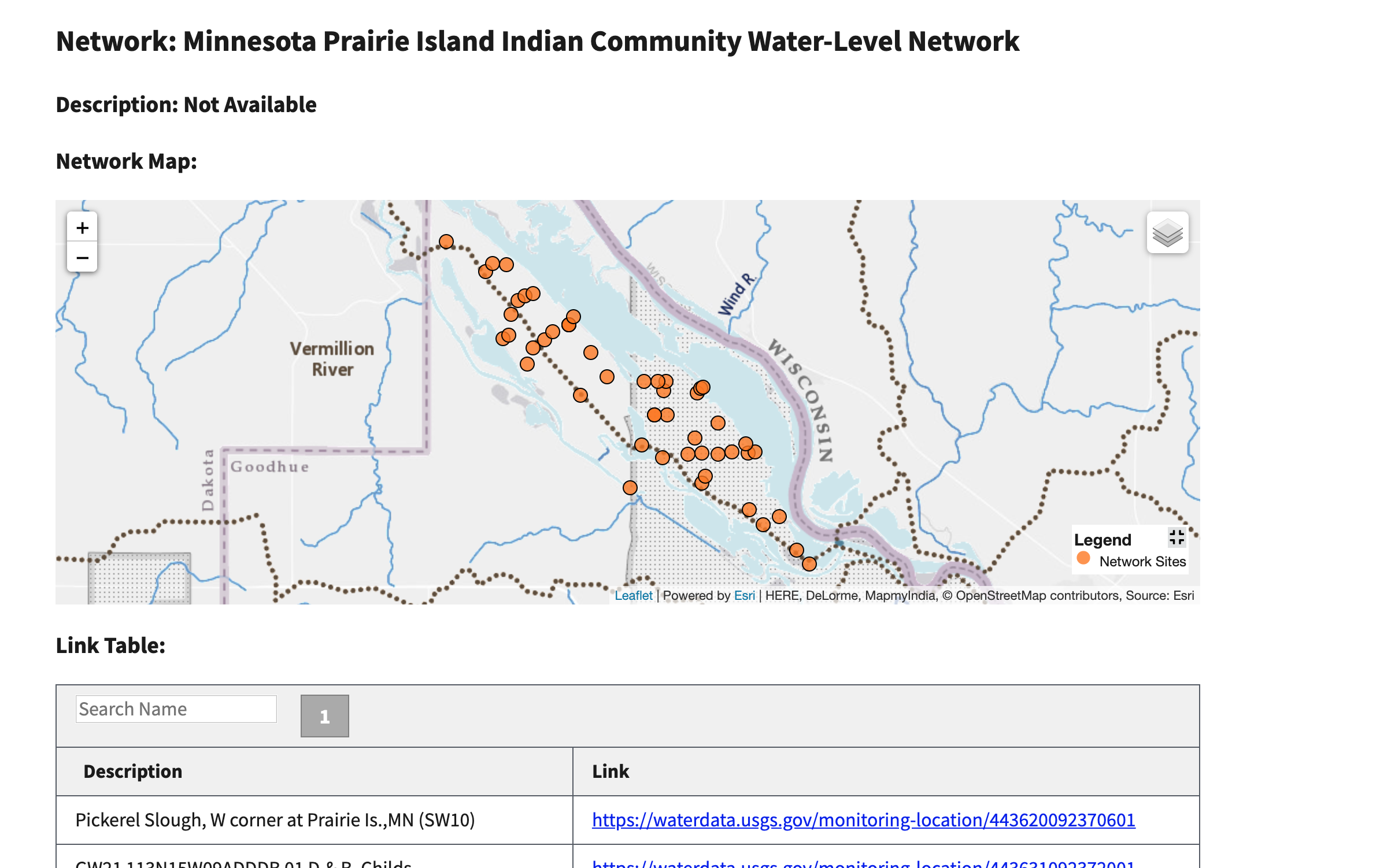
A screenshot of the page for the Minnesota Prairie Island Indian Community Water-Level Network
These pages are only the beginning. Features that we plan to add in the short term include:
- Populating existing networks with descriptions and other metadata
- Cooperator names, links and logos
- Extended descriptions of networks
- Contact information for networks
- Adding additional networks
- Linking back to the networks from each of the monitoring location pages that are part of each network.
Eventually, we are planning on adding a variety of other kinds of networks, including
- networks of monitoring locations with particularly high or low flow
- networks of particular interest, such as the Federal Priorities Streamgages
- short term networks based on specific events, like those that can be seen on the Flood Event Viewer .
There will be a lot more discussions about networks in the coming months and years!
What is coming up for next sprint?
- All monitoring locations will have a link to the networks it is part of in the new monitoring location service.
- Brush and legend added to Daily Value graphs on site pages
- Daily Value Maximum graphs for all groundwater sites with Daily Value levels data.
Disclaimer
Any use of trade, firm, or product names is for descriptive purposes only and does not imply endorsement by the U.S. Government.
Categories:
Keywords:
Related Posts
Release Notes for July 21st, 2020
July 21, 2020
What have we been up to? Pubs Warehouse moved to the Cloud Behind the scenes work New features and tools Pubs Warehouse on the Cloud The Water Data for the Nation team is the primary development team for another high profile application, the USGS Publications Warehouse .
Release Notes for late February and early March 2020
March 20, 2020
What have we been up to? Added handles to brush on the monitoring location page hydrograph State of hydrograph saved for bookmarking/linking Display upstream basin from NLDI for each monitoring location A number of additional graph server parameters New data services for monitoring locations Brush handles added to monitoring location page hydrograph Based on user feedback, the team upgraded the brush and zoom capability on the hydrograph by adding handles, making it more apparent that the zoom functionality is available and making it easier to use.
Release Notes for February 28th, 2020
March 2, 2020
The last several months have been exciting. We have been able to complete work related to: Cloud migration of the Water Quality Portal Cloud migration of the Network Linked Data Index (NLDI)
Release Notes for November 13, 2019
November 13, 2019
What have we been up to? This sprint, we have been working on a number of features that are the groundwork for future tools. Most notably, we are developing a working monitoring location services system based on the new Open Geospatial Consortium OGC API-Features standard .
Release Notes for October 16, 2019
October 16, 2019
What have we been up to? This sprint, the team has been working primarily on features that are tied to the cloud version of the USGS Publications Warehouse .