
Accessing discrete water quality and sample data on WDFN
The USGS just released new ways to access water quality and sample data in a recently expanded WQX data format.
Introduction
We are excited to share with you some updates to how USGS discrete (occurring as separate and distinct events) water quality and field sample (a.k.a. ‘samples’) data can be viewed and downloaded from the Water Data for the Nation (WDFN) website. This is the third blog in a series describing the updates to public samples data delivery. Our first installment briefly introduces the changes, and the second installment provides background on the new data delivery standard, called the Water Quality Exchange (WQX) standard. In summary, this post:
- Reviews the legacy web tools available for accessing samples data and why they are being retired
- Introduces three new web resources available on WDFN for viewing and accessing samples data
- Provides a glimpse into future resources, including APIs and a map-based download form, that are being built to give users more options for accessing USGS water data
Modernizing an aging system
The USGS National Water Information System (NWIS) has been undergoing a major, multi-year modernization that will enable us to more securely, reliably, and effectively deliver high-quality water data at a national scale. Historically, we delivered samples data using two main features:
- Web tables designed for viewing on a computer screen
- Data, either printed to a computer screen or as a download, in relational database (.rdb) format
The legacy samples websites have become difficult to update because they rely on aging technology. Therefore, we are modernizing delivery of samples data.
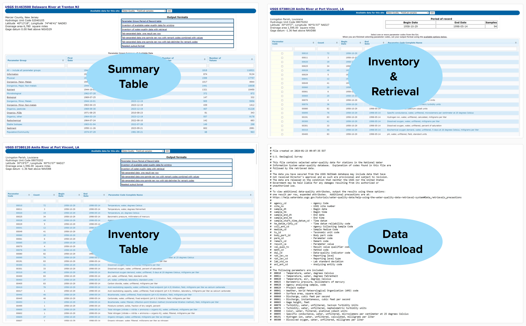
Features available in the Legacy NWISWeb site pages for viewing and accessing discrete water quality and field sample (‘samples’) data. The Summary table provides a quick glimpse of the types of data available (e.g. nutrients, biological) at a site over the period of record. The Inventory table shows data availability for each individual parameter over a site’s period of record. The Inventory and Retrieval table provides the additional option to select a subset of parameters for downloading. The data download options include viewing data directly on a computer screen or downloading as a tab-separated file in .rdb format, with options to provide the data in wide (one sample per row) or long (one result per row) orientation.
Modernized features for delivering samples data
With modernization, we are delivering samples data in new ways. Here’s an overview of the features available for accessing different information.
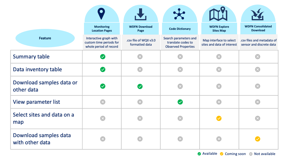
Summary of features available in WDFN for searching, viewing and accessing samples data.
View a summary of samples data
The Summary of Sample Data Table located on the Monitoring Location Pages allows users to view a summary of all available water quality and field sample data available at a monitoring location over the entire period of record. Users can get an idea about what data are available and decide whether to download the data.
Key features
- View a list of the available data for each observed property, the time period in which data are available and the number of result values or field visits (e.g. sampling activities).
- Page through the entire list of available samples data, or easily sort and filter the table based on the observed property or groups of observed properties (characteristic group).
- Easily initiate a data download by clicking on an observed property, which redirects to the new Download Discrete Sample Data page with your site and observed property pre-populated to make it easy to retrieve data of interest.
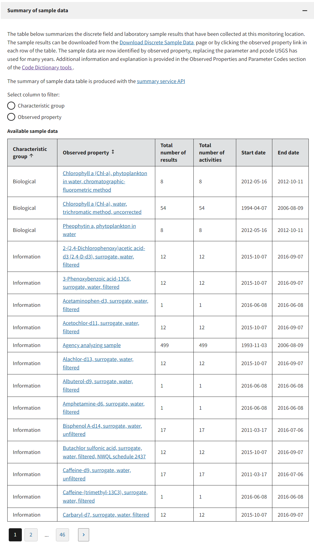
The Summary of sample data table as it appears for site No. 040851385, Fox River at Oil Tank Depot, Green Bay WI.
WDFN download discrete samples
The Download Discrete Sample Data page retrieves samples data for monitoring locations of interest.
Key features
Users can select data from one or many locations by providing a single identifier or list of identifiers. Queries can also be performed without a location filter to get data from all possible locations as long as a result filter is specified.
Users can also select locations within a geographic region such as US State or Hydrologic Unit code (HUC), or users can create a Bounding Box from a set of coordinates. Locations can be further filtered to specific Site Types (Stream, Well, etc.).
Users can further hone their data queries to retrieve results for samples by Sample media (water, biological tissue, soil, etc.), Observed properties or Characteristic group, and by date.
The returned data will follow the Water Quality Exchange (WQX) data standard that we describe in an earlier blog post . In brief, the WQX standard includes comprehensive metadata about a measurement or observation. Users will be able to choose a subset of the comprehensive list of metadata fields to download based on their needs and use cases. The options that are currently available are:
Monitoring locations – includes monitoring location information, including geospatial information, site type and aquifer data.
Sample results (full physical chemical) – includes results data and complete metadata for physical and chemical measurements and related metadata, as well as information about the project, location, and sampling activity.
Sample results (narrow) – includes results data for physical, chemical, and biological measurements and related metadata that are broadly useful for interpreting the results, as well as information about the project, location, and sampling activity.
Sampling activity – contains detailed information about water quality field collection events such as collection method and measurement depth.
Data can be downloaded in the comma separated (csv) file format for easily opening in different software such as MS Excel, R or Python.
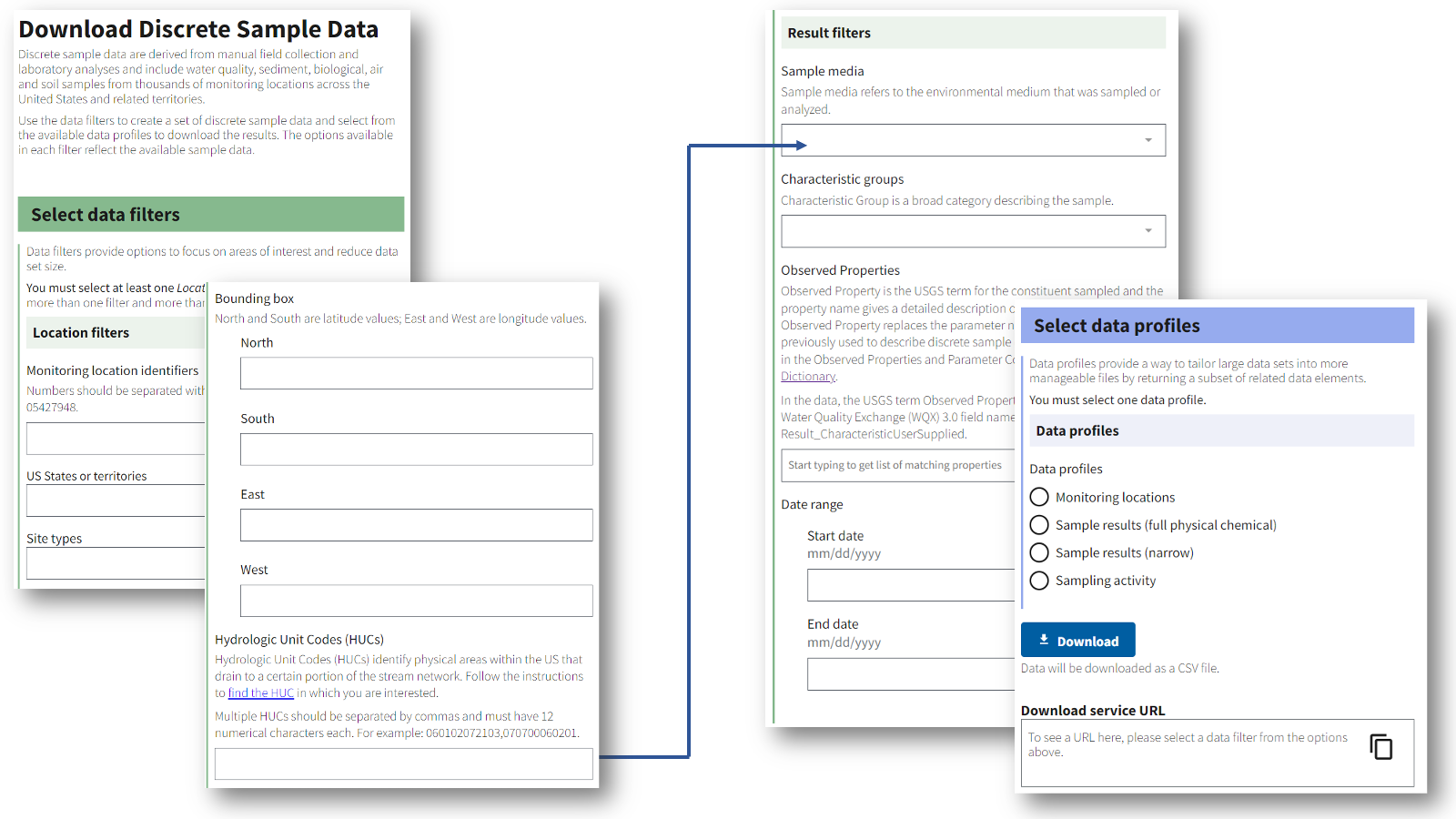
The Download Discrete Sample Data page available on WDFN.
Search parameters in the Code Dictionary
As we transition to serving data in a new format, we want to make it easy for users to know how the parameter codes (pcodes) will map to the new WQX metadata fields. The Code Dictionary provides a cross-reference between a USGS parameter code and the new USGS term called observed property (wondering what is an observed property? Check out this blog post).
Key features
Provides answers to basic questions about observed properties and parameter codes and how they relate to each other.
Enter a parameter code and have it translated into an observed property.
Enter an observed property and have it translated into the related parameter code(s)*.
View all available observed properties, with options to view a list of names in text or JavaScript array format, and to obtain the full list of observed properties with their parameter code relationships in JavaScript Object Notation (JSON) format.
Users can view the version date currently in use by the Code Dictionary, which is updated periodically.
*Note: Observed properties are not identical to parameter codes in the type of information they include, specifically they do not contain measurement units. A single observed property can be related to more than one parameter code.
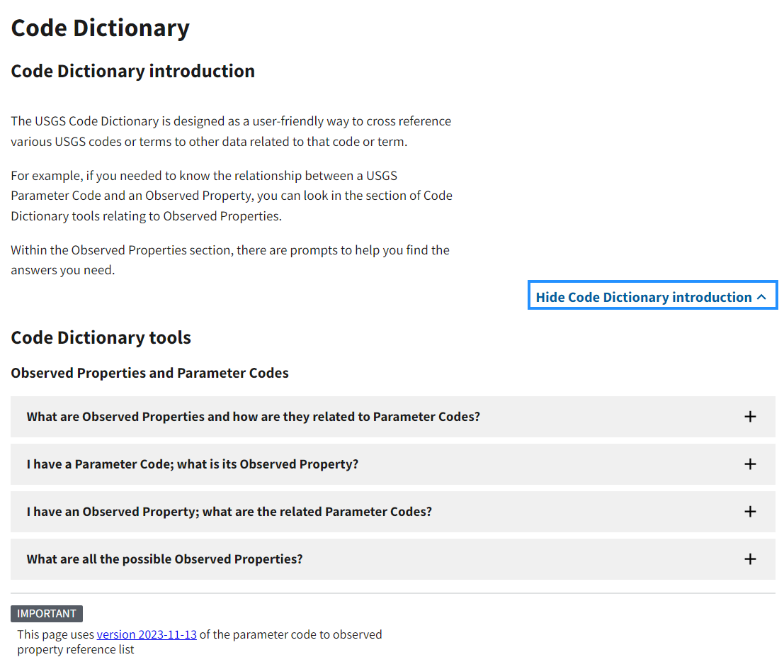
The Code Dictionary page available on WDFN.
Public API services
New APIs for samples data are in development. Stay tuned for updates.
As part of system modernization, existing API services for USGS discrete water quality and sample data from Period of Record queries using the Site service will change. On March 11, 2024, the Site Service no longer retrieved new or updated water quality and field samples data from queries using the Water quality samples/results filters (hasDataTypeCd=qw). No new data will be available using this request. Service responses will only return data available prior to this date.
Alternative services are being developed to enable users to obtain updated site-level water quality samples and results data. To stay up to date on services-related updates, please check out the waterservices documentation page at https://waterservices.usgs.gov/docs/ .
What’s next for samples data?
Explore and download USGS data
We are already working on a new map-based search feature to find locations that have data of interest. Users can search for data of various types including streamflow data and samples data all in the same map interface.
Once you’ve found the data of interest, you can then download the data in a single download package: no more downloading streamflow data and samples data separately!
Let us know how we’re doing
The features introduced in this blog will be in beta release. We’ll collect information on how they are working for users to better serve users’ needs. Please email us at wdfn@usgs.gov to let us know what you think.
Categories:
Related Posts
A tool to aid in the transition from the legacy NWIS discrete data format to the WQX format
September 15, 2024
Overview
Recently, the USGS modernized the format of its discrete water quality and sample data from a USGS-specific output format to the internationally recognized Water Quality Exchange (WQX) standard (for more background, read this blog post). Over many years, users have come to rely on USGS data from the NWIS
qwwebpage in a particular format for ongoing reporting and data analysis. Making the switch to a new format can be challenging, and we want to support users during this transition period. This blog post describes a resource (spreadsheet ) to help users access and use USGS discrete data in their existing workflows as they transition from legacy to modernized services.How the USGS uses the WQX standard
December 27, 2023
Overview
- The Water Quality Exchange (WQX) standard is an internationally recognized data standard that makes it easier to share and use water quality data
- The USGS is expanding its current use of the WQX standard from a relatively coarse mapping for data delivered on the Water Quality Portal (WQP) to a comprehensive mapping of USGS sample data on both the WQP and the modernized USGS data portal, Water Data For the Nation (WDFN)
- Overall, USGS metadata will be more visible to users and it will be human-readable
What is WQX?
The WQX schema is a standardized data exchange format specifically for sharing water quality observational data. This data standard was developed by the Environmental Protection Agency (EPA) in conjunction with the US Geological Survey and other partner environmental organizations. The WQX schema provides a set of metadata attributes that are foundational for understanding ambient water quality observations. Users can define information about who collected samples and where, results and metadata about samples, and information that helps to contextualize results, such as habitat assessment scores and metrics.
Improved Public Delivery of Water Quality and Field Samples Data
August 24, 2023
What are sample data?
Sample data are derived from manual field collection and laboratory analyses, including for water quality, sediment, biological, air and soil samples (waterdata.usgs.gov/nwis/qwdata ). Sample data do not include data collected by continuously-measuring instruments, data from models, or simulated data.
WQX3.0 Data Now Available on the Water Quality Portal
May 20, 2024
The Water Quality Portal (WQP) is the largest publicly available water quality data warehouse in the United States. It integrates publicly available data from many providers and outputs those data in a common format, known as the Water Quality Exchange (WQX) standard. Today, it contains hundreds of millions of water quality records from over 2 million locations. Visualizations such as Figure 1 can help to show the distribution of these records across the nation. Hundreds of organizations – including multiple federal agencies, every state and territory, many Tribal Nations, and community science groups – are currently sharing their water quality data with others through the WQP. This important data warehouse integrates and serves diverse physical, chemical, and biological water quality data (observations, measurements, and samples) in a very detailed and common format. The standard used to describe these data has been updated to a new version, WQX3.0. This data exchange standard supersedes prior versions (WQX1.0, WQX2.0, WQX2.1, and WQX2.2).
NWISWeb Decommission Campaign 1
December 6, 2024
Public USGS Webinar: Water Data for the Nation – New Features and NWISWeb Decommissioning
In this webinar, we highlight important changes in how we deliver water data. These changes are part of a long-term effort to modernize our Water Data for the Nation (WDFN) systems, improve performance, and better serve both internal and public users.