
Additional field measurements are coming to WDFN
Manual readings for additional water data parameters will be available beginning July 1st, 2026.
Water Data for the Nation (WDFN) publishes multiple categories of data collected at our monitoring locations, including both data collected by automated sensors and through manual methods. Manually collected data, which we refer to as “field measurements,” are collected during visits to a monitoring location.
Historically, WDFN (like NWISWeb before it) has published two categories of field measurement data: paired measurements of discharge and gage height (parameter codes 00060 and 00065, respectively) used to construct rating curves, and reference readings of groundwater levels (parameter codes 72019, 62610, and 62611) used primarily to calibrate automated sensors.
Beginning July 1st, WDFN will start publishing these reference readings for all parameter codes. This means that field measurement data will be available for the first time for new parameters, such as reservoir elevation, water temperature, and more. It also means that reference readings for discharge and gage height, used to calibrate automated sensors, will be available through WDFN alongside the current paired measurements used for rating curve construction. All previously available field measurements data will continue to be published.
These new field measurements will start appearing across WDFN pages, where they’ll be available for display on Monitoring Location Pages , My Favorites lists, and will be available for searches on the Explore USGS Water Data tool.
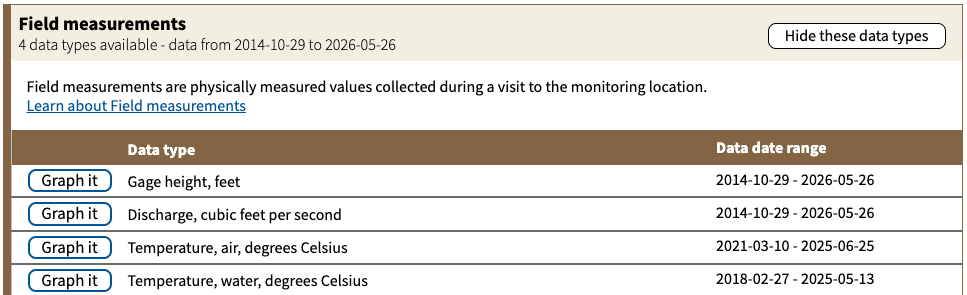
New field measurement series, like readings of air and water temperature, will display on Monitoring Location Pages alongside the already available discharge, gage height, and groundwater level series.
To help users distinguish the already available paired measurements of discharge and gage height used for rating curve creation from the potentially unpaired reference readings used to calibrate sensors, we’ve added a new “reading_type” field to data downloads from monitoring location pages, our Consolidated Download form
, and our field measurements
and field measurement metadata
API endpoints. This new reading_type field will have a value of ReferencePrimary for these new reference readings, while paired measurements will have values of Discharge and MeanGageHeight instead.
Newly collected field measurements will appear on WDFN beginning on July 1st, and historical readings will gradually be backfilled over the month of July. Please reach out to us wdfn@usgs.gov with any questions or feedback you may have.
Categories:
Related Posts
Daily data in Water Data for the Nation
November 21, 2025
There have been a lot of changes to how you access USGS water data as we work to modernize data delivery in WDFN and decommission NWISWeb. As we centralize and re-organize data delivery in WDFN, we have recently set out to describe different types of water data according to data collection categories . We started with re-organizing and expanding the data collection categories that are delivered on the Monitoring Location Page and are now working to deliver additional data collection categories on other WDFN pages as well. This blog is part of a series to help orient you to where you can find different types of data in WDFN pages and services. In this post, we want to focus on how you can access daily data in WDFN.
New Feature - Field Measurements
September 23, 2025
We are excited to announce a new feature on Monitoring Location pages that provide field measurements, which are physically measured values collected during a field visit to a monitoring location.
Modernization of Statistical Delivery and WaterWatch Decommission
June 10, 2025
USGS is modernizing how statistical information is delivered through a suite of new features and products. These are replacing WaterWatch , which offered unique statistics delivery that differentiated it from the core data delivery through legacy NWISWeb. WaterWatch and Water Quality Watch are set to be decommissioned by the end of 2025 as new products become available. This blog details where you can find the statistics previously offered on WaterWatch.
Big changes to USGS Water Data
May 28, 2025
Public USGS Webinar: Water Data for the Nation – New Features and NWISWeb Decommissioning
In this webinar, we highlight important changes in how we deliver water data. These changes are part of a long-term effort to modernize our Water Data for the Nation (WDFN) systems, improve performance, and better serve both internal and public users.
Modernized access for USGS rating curves is now available
April 28, 2026
Modernized access for USGS rating curves is now available
The USGS publishes rating curves describing the relationship between stage and streamflow at a monitoring location. Historically, these curves have been published at the NWISWeb Ratings Depot, available at https://waterdata.usgs.gov/nwisweb/get_ratings .