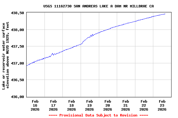
USGS 11162730 SAN ANDREAS LAKE A DAM NR MILLBRAE CA

PROVISIONAL DATA SUBJECT TO REVISION

Available Parameters Available Period
  
2019-04-25  2024-03-28
2019-04-25  2024-03-28


 (7)
 

  -- or --


Summary of all available data for this site
Instantaneous-data availability statement


Lake or reservoir water surface elevation above NGVD 1929, feet

Most recent instantaneous value: 438.60 03-28-2024   01:45 PDT
Graph of  Lake or reservoir water surface elevation above NGVD 1929, feet

Add up to 2 more sites and replot for "Lake or reservoir water surface elevation above NGVD 1929, feet"

?


Create presentation-quality / stand-alone graph.   Subscribe to WaterAlert      

See this graph on the Monitoring Location Pages


Lake or reservoir water surface elevation above NAVD 1988, feet, [Published]

Most recent instantaneous value: 441.26 03-28-2024   01:45 PDT
Graph of  Lake or reservoir water surface elevation above NAVD 1988, feet, [Published]

Add up to 2 more sites and replot for "Lake or reservoir water surface elevation above NAVD 1988, feet, [Published]"

?


Create presentation-quality / stand-alone graph.   Subscribe to WaterAlert      

See this graph on the Monitoring Location Pages