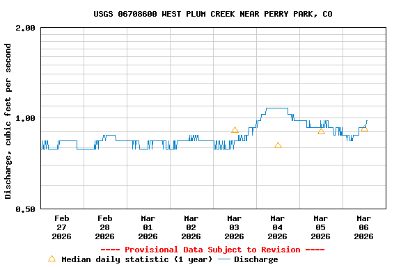
Most recent instantaneous value: 0.88 03-06-2026 06:30 MST
See this graph on the Monitoring Location Pages
| Most Recent Instantaneous Value Mar 6 | Mean | Min (2011) | Median | Max (2011) |
|---|---|---|---|---|
| 0.88 | 0.92 | 0.92 | 0.92 | 0.92 |
| Most Recent Instantaneous Value Mar 6 | Mean | Min (2011) | Median | Max (2011) |
|---|---|---|---|---|
| 0.88 | 0.92 | 0.92 | 0.92 | 0.92 |
![]() U.S. Department of the Interior |
U.S. Geological Survey
U.S. Department of the Interior |
U.S. Geological Survey
Title: USGS Current Conditions for Colorado
URL:
Page Contact Information: Colorado Water Data Support Team
Page Last Modified: 2026-03-06 09:45:03 EST
1.1 0.82 vaww01