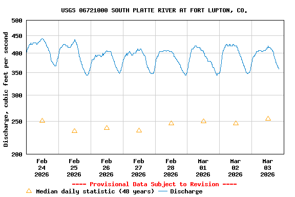
USGS 06721000 SOUTH PLATTE RIVER AT FORT LUPTON, CO.

PROVISIONAL DATA SUBJECT TO REVISION

This station managed by the Lakewood Field Office.

Available Parameters Available Period
  
2003-04-29  2025-12-17
2020-11-20  2025-12-17


 (7)
 

  -- or --


Summary of all available data for this site
Instantaneous-data availability statement


Discharge, cubic feet per second

Most recent instantaneous value: 374 12-17-2025   09:00 MST
Graph of  Discharge, cubic feet per second

Add up to 2 more sites and replot for "Discharge, cubic feet per second"

?


Create presentation-quality / stand-alone graph.   Subscribe to WaterAlert      

See this graph on the Monitoring Location Pages


Daily discharge, cubic feet per second -- statistics for Dec 17 based on 47 water years of record more
Min
(1955)
25th
percen-
tile
Median Mean 75th
percen-
tile
Most Recent
Instantaneous
Value Dec 17
Max
(2007)
72.0 120 207 224 308 374 494