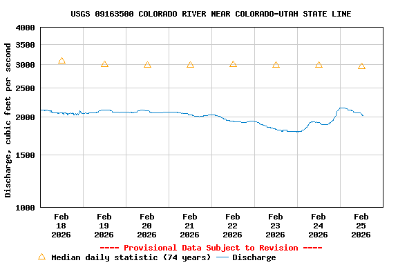
USGS 09163500 COLORADO RIVER NEAR COLORADO-UTAH STATE LINE
PROVISIONAL DATA SUBJECT TO REVISION
Available data for this site
SUMMARY OF ALL AVAILABLE DATA
Time-series: Current/Historical Observations
Time-series: Daily data
Time-series: Daily statistics
Time-series: Monthly statistics
Time-series: Annual statistics
Surface-water: Peak streamflow
Surface-water: Field measurements
Water-Quality: Field/Lab samples
Water-Year Summary
Revisions
This station managed by the Grand Junction Field Office.
Available Parameters
Available Period
All 7 Available Parameters for this site
00010 Temperature, water
1992-10-01
2025-12-15
00060 Discharge
1985-10-02
2025-12-15
00065 Gage height
2020-07-21
2025-12-15
00095 Specific cond at 25C
1992-10-01
2025-12-15
00300 Dissolved oxygen
2021-05-27
2025-12-15
00400 pH
2021-05-27
2025-12-15
63680 Turbidity, Form Neph
2021-05-27
2025-12-15
Output format
Graph
Graph w/ stats
Graph w/o stats
Graph w/ (up to 3) parms
Table
Tab-separated
Days
(7)
-- or --
Begin date
End date
Summary of all available data for this site
Instantaneous-data availability statement
Discharge, cubic feet per second
Most recent instantaneous value: 2300 12-15-2025 12:45 MST
Add up to 2 more sites and replot for "Discharge, cubic feet per second"
?
Add site numbers
Note
'Enter up to 2 site numbers separated by a comma. A site number consists of 8 to 15 digits'
Create
presentation-quality
/
stand-alone
graph. Subscribe to
?
WaterAlert
See this graph on the
Monitoring Location Pages
Share this graph
|
Daily discharge, cubic feet per second -- statistics for Dec 15 based on 74 water years of record
more
Min
(1964)
Most Recent
Instantaneous
Value Dec 15
25th
percen-
tile
Median
Mean
75th
percen-
tile
Max
(1987)
1910
2300
2540
3200
3380
4090
5970