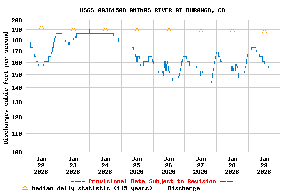
USGS 09361500 ANIMAS RIVER AT DURANGO, CO

PROVISIONAL DATA SUBJECT TO REVISION

Click to hidestation-specific text
Click for larger image

Station operated by the U.S. Geological Survey in cooperation with Bureau of Reclamation, Southwestern Water Conservation District, Animas La-Plata Operation, Maintenance, & Replacement Association, and The Town of Durango. The Colorado Department of Public Health and Environment provides funding for the water quality data.

Current shift adjusted rating table.
What is a shift adjusted stage-discharge rating table?

Boating safety tips

This station managed by the Durango Field Office.

Available Parameters Available Period
  
2016-04-06  2024-06-13
1985-10-02  2024-06-13
2020-09-23  2024-06-13
2016-04-06  2023-11-16
2016-04-06  2024-06-13
2016-04-05  2024-06-13


 (7)
 

  -- or --


Summary of all available data for this site
Instantaneous-data availability statement


Discharge, cubic feet per second

Most recent instantaneous value: 2380 06-13-2024   08:30 MDT
Graph of

Add up to 2 more sites and replot for "Discharge, cubic feet per second"

?


Create presentation-quality / stand-alone graph.   Subscribe to WaterAlert      

See this graph on the Monitoring Location Pages


Daily discharge, cubic feet per second -- statistics for Jun 13 based on 112 water years of record more
Min
(2002)
25th
percen-
tile
Most Recent
Instantaneous
Value Jun 13
Median Mean 75th
percen-
tile
Max
(1921)
358 1660 2380 2610 2970 3920 9100


Gage height, feet

Most recent instantaneous value: 4.54 06-13-2024   08:30 MDT
Graph of

Add up to 2 more sites and replot for "Gage height, feet"

?


Create presentation-quality / stand-alone graph.   Subscribe to WaterAlert      

See this graph on the Monitoring Location Pages