USGS 09058000 COLORADO RIVER NEAR KREMMLING, CO

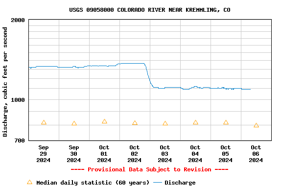
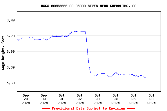
PROVISIONAL DATA SUBJECT TO REVISION

Click to hidestation-specific text
Click for larger image

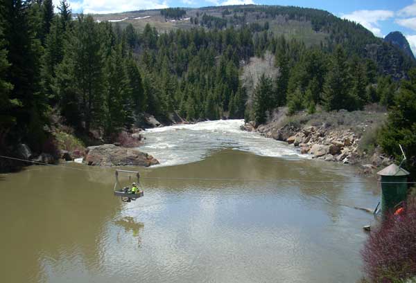
Station operated by the U.S. Geological Survey, Colorado Water Science Center, as part of the USGS National Streamflow Information Program (NSIP).

The water temperature at this site is operated seasonally, April through September only.

The Unit Value precipitation data for this station are temporary and will only be displayed for 120 days. (more information)

Current shift adjusted rating table.
What is a shift adjusted stage-discharge rating table?

Boating safety tips

This station managed by the Lakewood Field Office.

Available Parameters Available Period
  
2008-04-01  2023-05-31
2023-04-01  2023-05-31
1986-10-01  2023-05-31
2020-10-08  2023-05-31
2022-04-30  2023-05-31
2022-04-30  2023-05-31
2022-04-30  2023-05-31
2022-04-30  2023-05-31


 (7)
 

  -- or --


Summary of all available data for this site
Instantaneous-data availability statement


Discharge, cubic feet per second

Most recent instantaneous value: 1520 05-31-2023   17:15 MDT
Graph of

Add up to 2 more sites and replot for "Discharge, cubic feet per second"

?


Create presentation-quality / stand-alone graph.   Subscribe to WaterAlert      

See this graph on the Monitoring Location Pages


Daily discharge, cubic feet per second -- statistics for May 31 based on 60 water years of record more
Min
(2002)
25th
percen-
tile
Most Recent
Instantaneous
Value May 31
Median Mean 75th
percen-
tile
Max
(1984)
280 874 1520 1740 2290 3090 9630


Gage height, feet

Most recent instantaneous value: 6.54 05-31-2023   17:15 MDT
Graph of

Add up to 2 more sites and replot for "Gage height, feet"

?


Create presentation-quality / stand-alone graph.   Subscribe to WaterAlert      

See this graph on the Monitoring Location Pages